Thematic Focus: Climate Change, Resource Efficiency, Ecosystem Management, and Environmental Governance
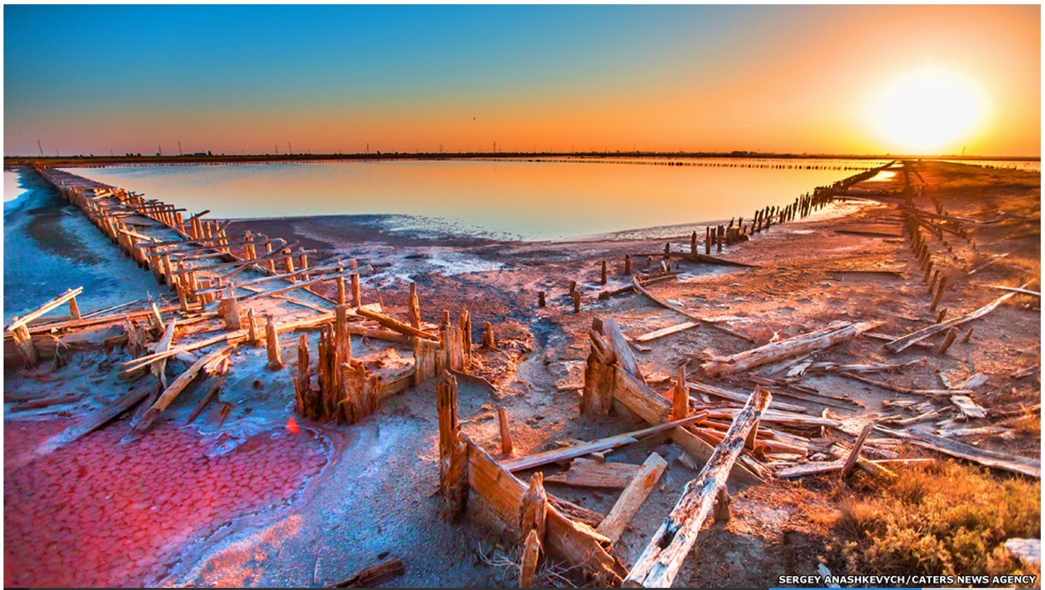
This photo along the lake’s shoreline shows the salt left behind as the lake retreats. Photo Source: Wikipedia
The lake's surface area has been estimated to have been as large as 6 100 km² but since 1995 it has generally been declining (9) and was estimated from satellite data to be only 2 366 km² in August of 2011 (Landsat data). The decline is generally blamed on a combination of drought, increased water diversion for irrigated agriculture within the lake's watershed and mismanagement (2,9,10,1). In addition, a causeway has been built across the lake with only a 1 500 m gap for water to move between the northern and southern halves of the lake (9). It has been suggested that this has decreased circulation within the lake and altered the pattern of water chemistry; however evidence suggests that the impact of the causeway on the uniformity of water chemistry in the lake has been minimal (11,9,10,12). The unfolding ecological disaster threatens to leave much of the lake bed a salt-covered wasteland. Scientists have warned that continued decline would lead to increased salinity, collapse of the lake's food chain and ecosystem, loss of wetland habitat, wind blown "salt-storms," alteration of local climate and serious negative impacts on local agriculture and livelihoods as well as regional health (10,9,1,13).
Thousands of protesters took to the streets in the cities of Tabriz and Urmia in late August and early September 2011 saying that authorities have done too little to save the lake (14,15,16). Those around the lake fear a fate similar to that of the population surrounding the nearby Aral Sea, which has dried up over the past several decades. Disappearance of the Aral Sea has been an environmental disaster affecting people throughout the region with windblown salt-storms. The population surrounding Lake Urmia is much denser putting more people at risk of impact.
A Unique Lake
Lake Urmia is an endorheic or terminal lake meaning that water leaves the lake only by evaporation. As is generally the case, this leads to a saltwater body and in the case of Lake Urmia, salinity is quite high. The lake has dramatically decreased in volume over the past decade-and-a-half, further concentrating salts in the lake, raising salinity to more than 300 g/L (9) or 8 times as salty as typical seawater. Aquatic biodiversity is limited by the lake's salinity and Lake Urmia does not support any fish or mollusk species and no plants other than phytoplankton within the lake (17,18,19,12). Wetlands surrounding the lake support a variety of salt tolerant plant species (19). There is significant phytoplankton growth, with reports of some dense algae blooms occurring during years with low salinity (9). The most significant aquatic biota in the lake is a brine shrimp species, Artemia urmiana. This macro-zooplankton species is the key link in the lake's food chain, consuming algae and in turn being consumed by several bird species including the Lake's migratory flamingo population (19). The diverse bird population of Lake Urmia and its associated wetlands was documented in a series of surveys in the 1970s which recorded an impressive list of species (7).
A Rapid Decline
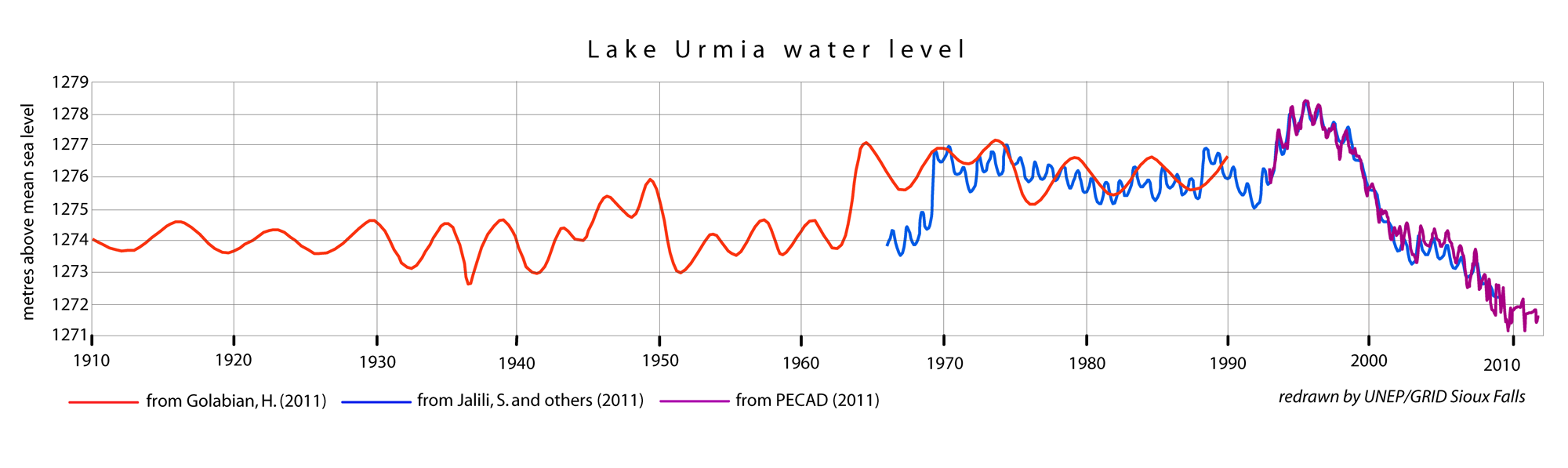
Satellite altimeter data measured the lake's level in 1995 to be at its highest level of any time in the past 40 years (Figure 1) (21,4). This is in agreement with Hassanzadeh and others (2011) who state a measured water level of roughly 1 278 m above sea level for the same time. Both measures show a steady decline from that year forward with the most recent satellite altimeter data indicating a drop of approximately 7 metres between 1995 and 2011 (21).
Figure 1: Overlaying multiple records of the lake's surface elevation shows generally good agreement. These data suggest that sometime around 2008, Lake Urmia declined below any point in the past 100 years of recorded lake levels and well below the long term average.
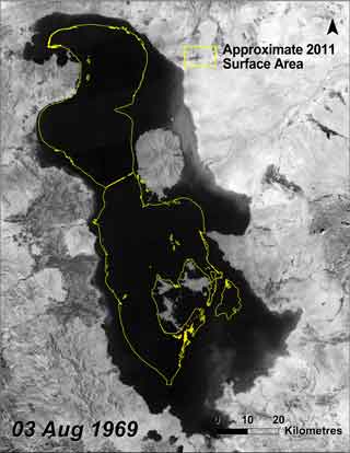
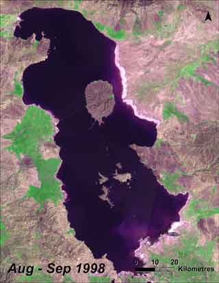
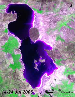
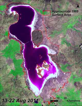
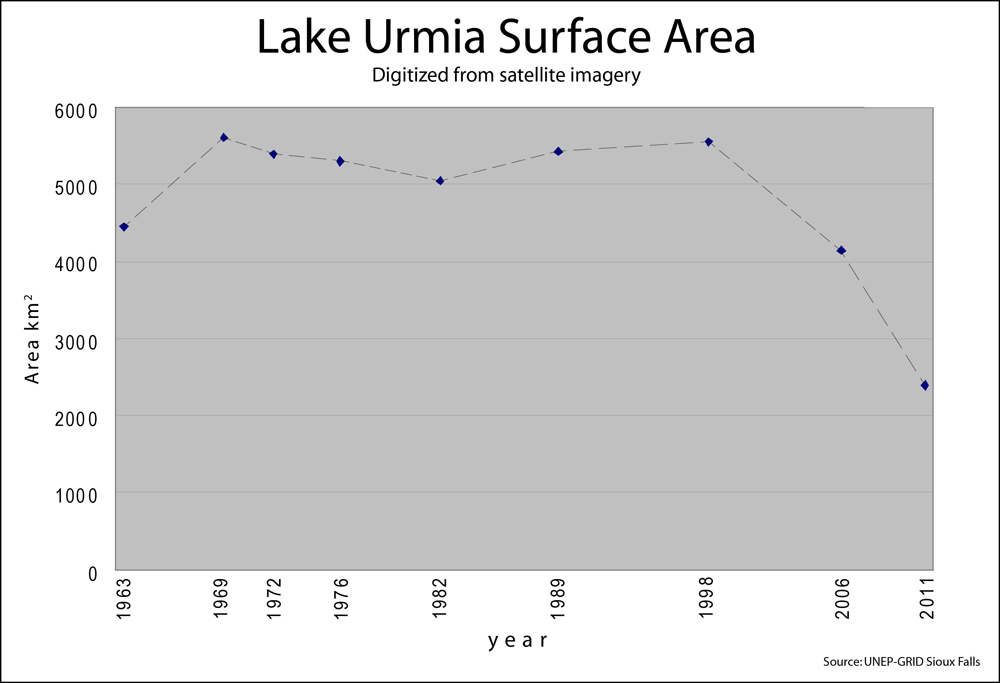
Figure 2: Surface area estimated from Landsat satellite imagery.
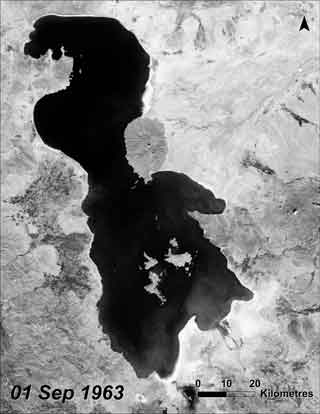
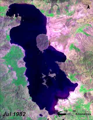
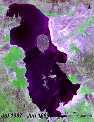
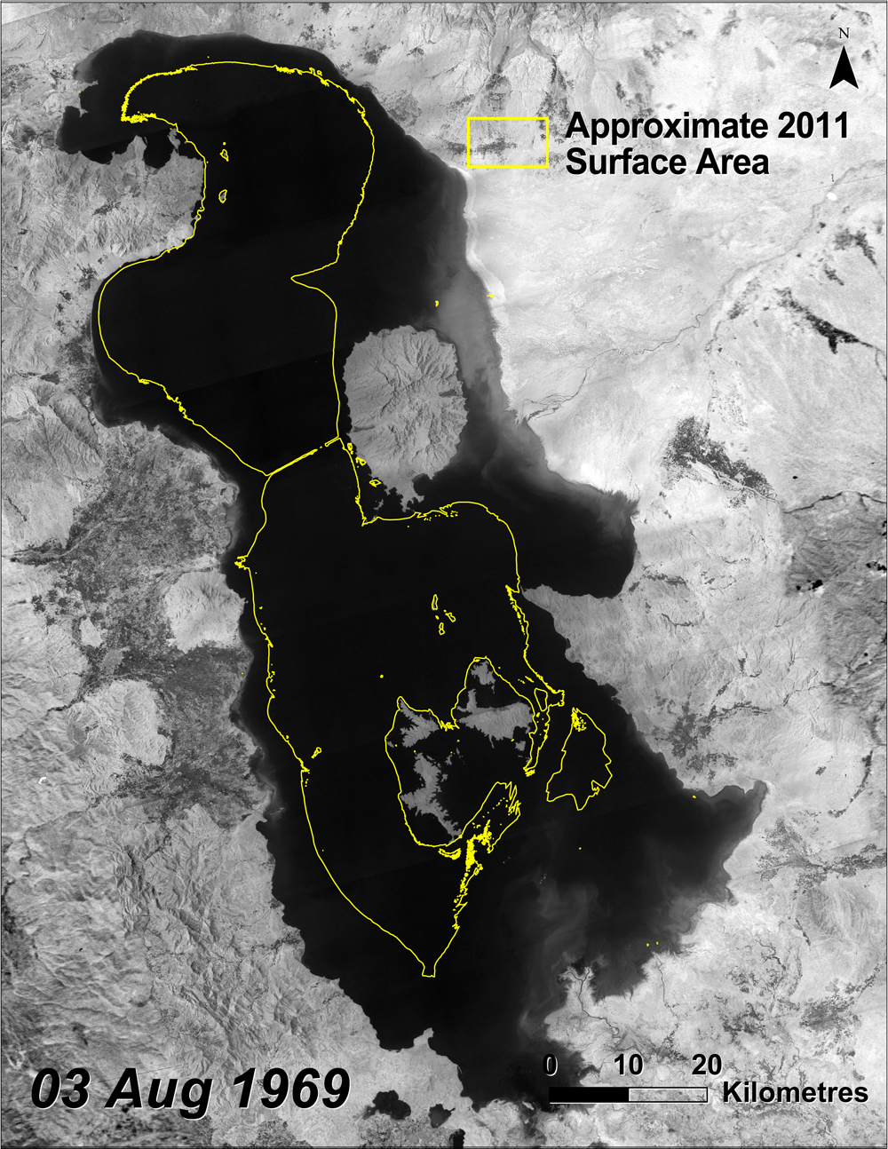
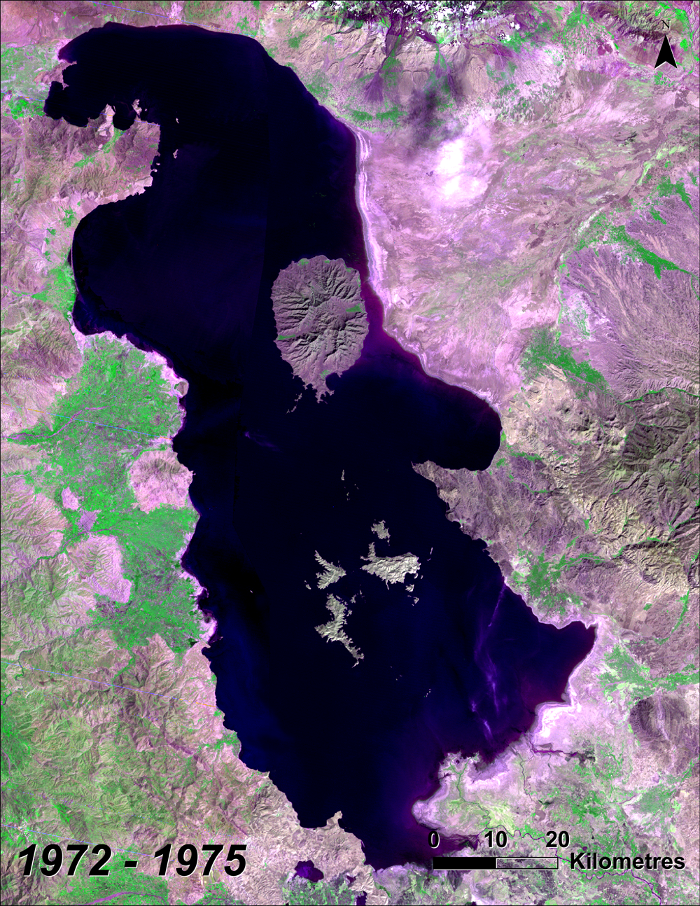
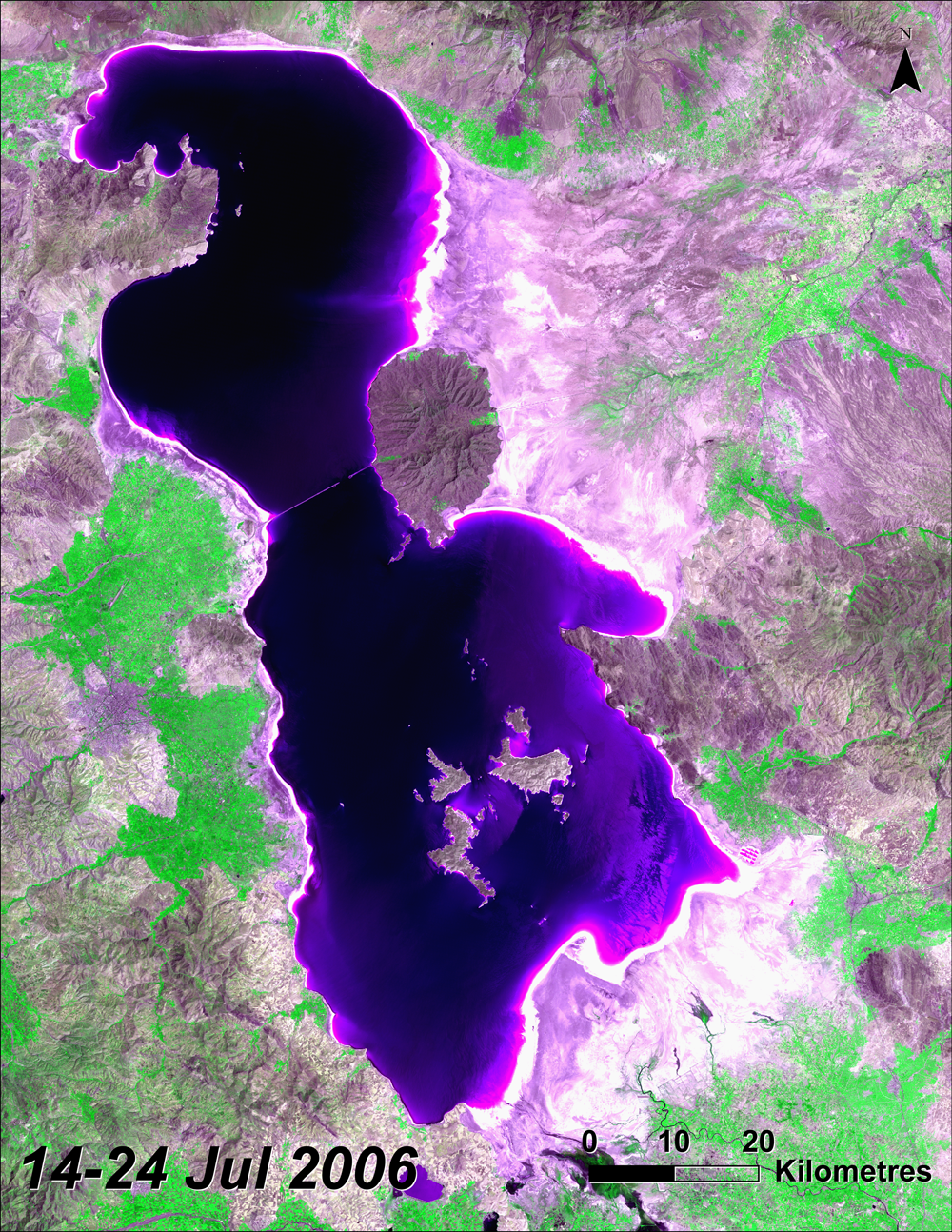
Because the lake is relatively shallow, this decline in water level translates to an equally dramatic decline in surface area (Figures 2 & 3). Satellite imagery extending back to the early 1960s shows the lake's area to have been somewhat smaller in 1963, growing to almost 6 000 km² in 1969, and then remaining generally stable from the late 1960s to the mid-1990s. Since peaking in the mid-1990s, surface area has generally declined quite rapidly despite regular seasonal variation and a brief expansion during a wet period in the early 2000s.
Variability of the lake prior to the early 1960s does not appear to have been widely studied, however, a generalized plot of lake levels dating back to the early 1900s shows only one brief period in 1937 where the lake declined to below 1 273 m above sea level, and then for less than one year (Figure 1)(10). The recent decline reached 1 273 m above sea level in 2008 and, based on satellite images of surface area, the trend has continued through seasonal ups and downs to where current water levels appear to be approaching 1.5 metres lower than at any time in over 100 years (21,22).
Source: 1963 Image: ARGON data from USGS; 1969 image: Corona data from USGS, visualization by UNEP GRID Sioux Falls; 1972-2011 images: landsat data, 2011 image: visualization by UNEP GRID Sioux Falls.
Causes of the Decline
Because Lake Urmia is a terminal lake with no significant water outflow the only way water leaves the lake is by evaporation. Therefore, if the lake declines it is either by increased evaporation or a decrease in water coming into the system. The Zarrineh Rood River is the largest of the thirteen main rivers discharging into Lake Urmia which are the source of the majority of the Lake's water budget (18,9). Additional input comes from rainfall directly over the lake, floodwater from the immediate watershed and a very small fraction from groundwater flow (9,18).
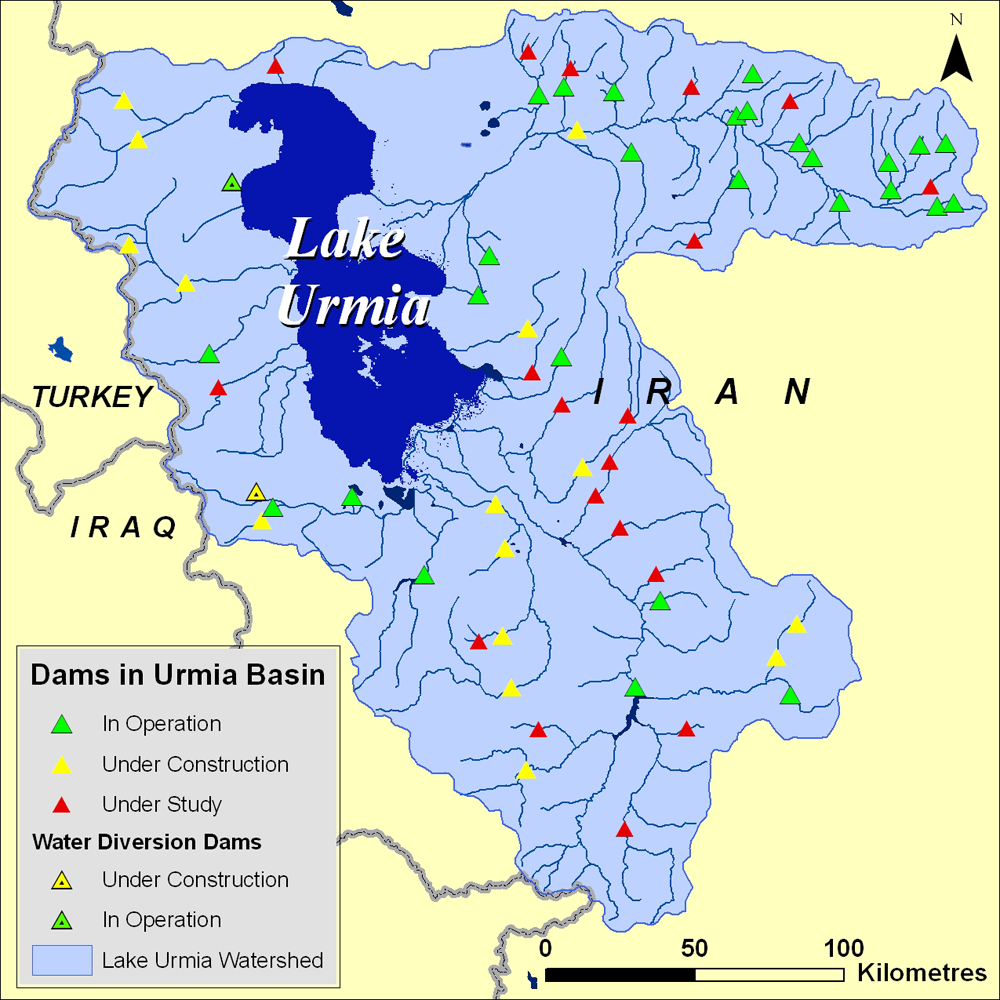
Figure 4: The number of dams (existing, under construction and under study) within the lake's basin suggest an increase in diversion of surface water beyond current levels which already appear to be unsustainable. Source: Hassanzadeh and others (2011), redrawn by UNEP GRID Sioux Falls
A study modeling the relative influence of various factors on the decline of Lake Urmia found that 65 per cent of the decline was from changes in inflow caused by climate change and diversion of surface water for upstream use, with the remaining balance due to construction of dams (25%) and decreased precipitation over the lake itself (10%) (2). Several other studies also suggest that this diversion of water has been the one of the most, if not the most, significant cause of Lake Urmia's decline with other contributing causes being reduced precipitation, warmer temperatures and groundwater abstraction (9,23,13,24).
The average annual rainfall within the basin from 1967 to 2006 was 235 mm, with variation between about 440 mm in 1968 to less than 150 mm in 2000 (2). Annual rainfall was 40 mm less on average in the basin for the last decade of that period (1997-2006) than it had been for the first 30 years (1967-1996) (2). The arid to semi-arid climate of the basin means that agriculture is largely dependent on irrigation. The decrease in precipitation along with declining groundwater levels in this area (25,1) and a growing population of 6.5 million people within the watershed (8) will likely exert increasing pressure to continue diverting streamflow within the basin before it reaches Lake Urmia.
Serious Impacts
Reduced water volume in the lake has already concentrated the existing salts to 300 g/L or higher in many locations. Sodium chloride concentrations much over 320 g/L are believed to be fatal to the lake's brine shrimp. Optimal conditions for Artemia urmiana appear to be at salt concentrations well under 200 g/L and as salinity rises much above this level, there is a measured negative impact on growth rate, reproduction and mortality (27,19,26). Based on in situ observations of the brine shrimp populations under varying salinities in Lake Urmia, it has been suggested that a concentration of 240 g/L or less would be required to sustain a viable population (19).
Figure 5: The land left behind as the lake retreats is covered with salt deposits that make it unusable for agriculture. The causeway across the lake can be seen in the lower right of the image.
The lake's brine shrimp are the sole link between the primary production of the lake's algae and the diverse migratory bird population which feeds on these shrimp (19,1,27). Because the brine shrimp occupy this crucial link in the ecosystem their demise would translate into the likely loss of many of Lake Urmia's migratory bird populations and affect the entire ecosystem's sustainability (19,10). Any current or future tourist trade focused on these bird populations would likely also decline dramatically.
As lake levels decline, the exposed lakebed is left with a covering of salts, primarily sodium chloride, making a great salty desert on much of the 400 km² of lost surface area (Figure 5) (10). These salt flats will not support agriculture and inhibit growth of most natural vegetation. The salts are also susceptible to blowing and will likely create "salt-storms" like the ones that have resulted from the drying of the Aral Sea, located 1 200 km to the northeast of Lake Urmia (10). Blowing salts from the Aral Sea have been linked to vegetation-mortality in some cases or, more frequently, reduced vegetation growth, reduced crop yields, ill effects on wild and domestic animals, respiratory illness, eye problems, and throat and esophageal cancer (28). Based on the experience of the Aral Sea salt storms, it is likely that many of the tens of millions of people who live within a few hundred kilometres of the lake will be close enough to experience the impact of these salt storms (28).
Increasing water demand and decreasing water supply
Agriculture surrounding the lake relies on irrigation with groundwater and surface water supplies, which are also being pressured by increasing demand for domestic supply (2). There is considerable evidence that groundwater resources are already being exploited at rates faster than aquifer recharge in the area of the Lake Urmia watershed (25,1). Surface water flows are being diverted for use at rates which do not allow adequate inflow to Lake Urmia to maintain the lake's current level(2,9,23,13). Water use within the Lake Urmia basin at current rates is unsustainable without loss of the lake, and the consequent environmental damage as well as damage to the surrounding population and agriculture. In very simple terms, Lake Urmia needs more water coming in—either from inside or from outside the basin—to avoid an environmental tragedy.
| 
|
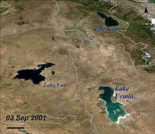
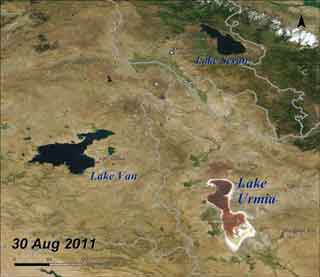
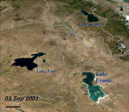
Figure 6: Two other lakes of similar size—Lake Sevan and Lake Van—and each less than 200 km from Urmia do not show the dramatic change apparent in Lake Urmia from 2001 to 2011. Both of these lakes are much deeper and thus generally less susceptible to rapid loss of surface area due to decreased inflow. Lake Urmia, being the shallowest of the three, has responded relatively quickly to the diversion of streamflow by the many dams built in the Urmia basin. Source: Modis Data from NASA, visualization by UNEP GRID Sioux Falls
The two principal approaches to the problem are to adjust water allocation within the basin to allow an adequate environmental flow for sustaining Lake Urmia and/or to import water from outside the basin which would increase water levels and dilute salinity within the lake.
Reducing the amount of water diverted for agriculture, domestic and industrial use, or at least curtailing the growth in these water uses, may help stop or slow the decline of Lake Urmia (2). Abbaspour and Nazaridoust (2007) have produced an estimate of inflow required to maintain the lake. They estimate that an annual volume of 3 085 million cubic metres would be the ecological water requirement of Lake Urmia which would "keep the ecological functions of the lake sustainable" and allow the survival of a viable Artemia urmiana population. Another study estimates the needed maintenance volume to be in the same range, at between 2 600 and 4 200 million cubic metres per year, but also points out that larger inflow would be required to accelerate the recovery during an initial period of several years (10). The problem with this solution is the heavy reliance of the region's agriculture on surface flow for irrigation water. Some water could be saved through increased efficiencies and improved management (2). However, with a growing population, continuing dam and irrigation development and especially if recent trends in rainfall and temperature continue, this will likely prove to be unpopular, impractical and—on its own—an inadequate solution (10,2).

The causeway and bridge built across Lake Urmia was completed in November 2008. There is concern that it inhibits circulation within the lake and may exacerbate environmental issues caused by the lower water levels. Photo Source: Wikipedia
The other widely suggested solution is to divert water from elsewhere to make up for the lost water volume no longer reaching the lake. A few possible sources have been put forward including the Zab River (9), the Aras River and the Caspian Sea. Inter-basin transfer of water may be the solution which holds the most promise of rescuing Lake Urmia, due to the large volume of water that would be needed. In the case of the Caspian Sea however, the distance of the proposed transfer route is around 300 km and the cost has been estimated at around 4 to 5.5 billion US $ (10). In addition, the timeframe for completing such a project has been estimated to be around 5 years and even the most aggressive rates of transfer would take an additional year to restore lake level to what it was in 2003 (10). Finally, transfer from the Caspian Sea would require negotiated agreements with the other countries which border the sea. So far talks have been unsuccessful in reaching an accord (29). While transfers from other river basins in the region could be less time consuming and expensive the total volume of water available would be limited, and by some accounts would be inadequate (10). The relatively smaller potential volume would also mean a greater possibility that transfers could impact the source basins negatively. The Zab River Basin is located in Turkey and Iraq and would require cooperation of those two countries. The Aras River Basin is split roughly in half between Iran and Azerbaijan. News reports suggest that talks have been initiated between the two countries regarding the use of Aras water for transfer to Lake Urmia (30).
Another strategy for bringing additional water into the basin is cloud seeding—attempting to increase precipitation by dispersing substances into clouds (10). Some projects are "under study and operation" (2), however cloud seeding in general is controversial and its impact limited (31,32) making this a partial and uncertain solution at best.
Main findings and implications
Lake Urmia's water level has rapidly declined since the mid-1990s after having remained relatively stable over the 30 prior years. Construction of dams and diversion of surface water for agriculture, along with reduced precipitation and warmer temperatures over the basin, and to a lesser extent reduced inflow of groundwater are generally accepted as the causes (9,2,13). Reduced water volume concentrates the salts in the lake making it too saline for the brine shrimp which—being near the bottom of the simple food chain—support the very diverse bird population for which the lake provides important habitat. The surrounding brackish wetlands with a productive and diverse plant population will also dry up under current trends and conditions. As the lake retreats from its original shoreline it leaves a layer of salt—primarily sodium chloride—which leaves the land unusable for agriculture and threatens to unleash damaging storms of wind-blown salt on the surrounding area. The lake's increasing salinity has reached near saturation at over 300 g/L and threatens to decimate the lake's brine shrimp population which is a key link in the ecology of the lake and surrounding wetlands. While effective integrated water management is called for by many, there are no easy answers. Water conservation within the basin might provide some relief. However, finding the volume of water needed to restore the lake, without going outside the watershed, would probably require allocating water away from important areas of irrigated agriculture. Water transfer from the Caspian Sea would be very expensive and time consuming and may come too late to avert damage to the ecosystem by the historically low water levels and high salinity that are already occurring. Diverting water from neighboring watersheds would be less costly and time consuming but also has some serious challenges. A comprehensive integrated water management plan would take all elements of the basin's water budget into account, balancing demands for irrigation, ecosystem preservation, social and human impact and water quality as well as operating within the national and regional political realities.
Prepared at UNEP-GRID Sioux Falls by Bruce Pengra with the invaluable input of Vahid Garousi PhD, PEng.-University of Calgary, Aref Seyyed Najafi, PhD-University of Calgary and Azar Samadi-Energy Consultant, Calgary Canada
Written by: Bruce Pengraa
Production and Outreach Team: Arshia Chanderc, Erick Litswad, Kim Giesec, Michelle Anthonyc,
Reza Hussainc, Theuri Mwangid
Special thanks to Vahid Garousic, Aref Seyyed Najafic and Azar Samadid for editorial review
(a UNEP GRID Sioux Falls, b UNEP Nairobi, c University of Calgary, d Consultant)
- Zarghami, M. (2011). Effective watershed management; Case study of Urmia Lake, Iran. Lake and Reservoir Management, 27(1), 87-94. doi: 10.1080/07438141.2010.541327.
- Hassanzadeh, E., Zarghami, M., Hassanzadeh, Y. (2011). Determining the Main Factors in Declining the Urmia Lake Level by Using System Dynamics Modeling. Water Resources Management, 26(1), 129-145. doi: 10.1007/s11269-011-9909-8.
- Karbassi, A., Bidhendi, G., Pejman, A., Bidhendi, M. (2010). Environmental impacts of desalination on the ecology of Lake Urmia. Journal of Great Lakes Research, 36(3), 419-424. doi: 10.1016/j.jglr.2010.06.004.
- Jalili, S., Kirchner, I., Livingstone, D., Morid, S. (2011). The influence of large-scale atmospheric circulation weather types on variations in the water level of Lake Urmia, Iran. [10.1002/joc.2422]. International Journal of Climatology, n/a-n/a.
- Ramsar (no date). Ramsar Site List. Accessed 24 January 24, 2012 at: http://www.unesco.org/mabdb/br/brdir/directory/biores.asp?mode=gen&code=IRA+07.
- UNESCO (no date). UNESCO-MAB Biosphere Reserves Directory. 24 January 24, 2012 at: http://www.unesco.org/mabdb/br/brdir/directory/biores.asp?mode=gen&code=IRA+07.
- Scott, D. (2001). The Birds of Lake Orumiyeh and Adjacent Wetlands, Islamic Republic of Iran – Results of Surveys carried out by the Ornithology Unit of the Department of the Environment in the 1970s. Accessed 24 January 2012 at: http://www.wetlands.org/reports/ris/2IR003_Annex.pdf.
- SEDAC (2010). Gridded Population of the World: Future Estimates. Socioeconomic Data and Applications Center (SEDAC); collaboration with CIESIN, UN-FAO, CIAT. Accessed December 14, 2011 at: http://sedac.ciesin.columbia.edu/gpw.
- Eimanifar, A. and Mohebbi, F. (2007). Urmia Lake (Northwest Iran): a brief review. Saline Systems, 3, 5. doi: 10.1186/1746-1448-3-5.
- Golabian, H. (2010). Urumia Lake: Hydro-Ecological Stabilization and Permanence Macro-engineering Seawater in Unique Environments (pp. 365-397). Berlin: Springer-Verlag. doi: 10.1007/978-3-642-14779-1_18.
- Zeinoddini, M., Tofighi, M., Vafaee, F. (2009). Evaluation of dike-type causeway impacts on the flow and salinity regimes in Urmia Lake, Iran. Journal of Great Lakes Research, 35(1), 13-22. doi: 10.1016/j.jglr.2008.08.001.
- Alipour, S. (2006). Hydrogeochemistry of seasonal variation of Urmia Salt Lake, Iran. Saline Systems, 2, 9. doi: 10.1186/1746-1448-2-9.
- Hoseinpour, M., Fakheri Fard, A., Naghili, R. (2010). Death Of Urmia Lake, a Silent Disaster Investigating Causes, Results and Solutions of Urmia Lake drying. Paper presented at the 1st International Applied Geological Congress, Department of Geology, Islamic Azad University, Islamic Azad University - Mashad Branch, Iran.
- Dehghan, S. (2011). "Iranian greens fear disaster as Lake Orumieh shrinks," The Guardian 5 September 2011. Accessed February 8, 2012 at: http://www.guardian.co.uk/world/2011/sep/05/iran-greens-lake-orumieh-shrinks.
- Mackey, R. (2011). "Protests in Iran Over Disappearing Lake," The Lede / NYTimes 30 August 2011. Accessed February 8, 2012 at: http://thelede.blogs.nytimes.com/2011/08/30/protests-in-iran-over-disappearing-lake/.
- Euronews (2011). "Dozens arrested in Iran over lake protest" Euronews 11 August 2011. Accessed February 8, 2012 at: http://www.euronews.net/2011/08/29/dozens-arrested-in-iran-over-lake-protest/.
- Ramsar (1997). Ramsar Information Sheet – Lake Oroomiyeh. Accessed 24 January 2012 at: http://www.wetlands.org/reports/ris/2IR003en.pdf.
- Ghaheri, M., Baghal-Vayjooee, M., Naziri, J. (1999). Lake Urmia, Iran: A summary review. International Journal of Salt Lake Research, 8, 19-22.
- Abbaspour, M. and Nazaridoust, A. (2007). Determination of environmental water requirements of Lake Urmia, Iran: an ecological approach. International Journal of Environmental Studies, 64(2), 161-169. doi: 10.1080/00207230701238416.
- Asri, Y. and Ghorbanli, M. (1997). The halophilous vegetation of the Orumieh lake salt marshes, NW. Iran. Plant Ecology, 132, 155-170.
- PECAD (no date). USDA/FAS/OGA and NASA Global Agriculture Monitoring (GLAM) Project. Lake and reservoir surface height variations from the USDA's Global Reservoir and Lake (GRLM) web site at: http://www.pecad.fas.usda.gov/cropexplorer/global_reservoir/. Altimetric lake level time-series variations from the Topex/Poseidon, Jason-1, Jason-2/OSTM, and Geosat Follow-On (GFO) missions.
- MODIS (no date). MODIS Satellite Data acquired from NASA Lance MODIS website at: http://lance-modis.eosdis.nasa.gov/cgi-bin/imagery/realtime.cgi.
- Reveshty, M. and Maruyama, Y. (2010). Study of Uremia Lake Level Fluctuations and Predict Probable Changes Using Multi-Temporal Satellite Images and Ground Truth Data Period (1976-2010). Paper presented at the Map Asia 2010 and ISG 2010, Kuala Lumpur, Malaysia.
- Ahmadi, R., Mohebbi, F., Hagigi, P., Esmailly, L., Salmanzadeh, R. (2011). Macro-invertebrates in the Wetlands ofthe Zarrineh estuary at the south of Urmia Lake. International Journal of Environmental Restoration, 5(4), 1047-1051.
- Wada, Y., van Beek, L., van Kempen, C., Reckman, J., Vasak, S., Bierkens, M. (2010). Global depletion of groundwater resources. Geophysical Research Letters, 37(20). doi: 10.1029/2010gl044571.
- Agh, N., van Stappen, G., Bossier, P., Sepehri, H., Lotfi, V., Razavi Rouhani, S., Sorgeloos, P. (2008). Effects of Salinity on Survival, Growth, Reproductive and Life Span Characteristics of Artemia Populations from Urmia Lake and Neighboring Lagoons. Pakistan Journal of Biological Sciences, 11(2), 164-172.
- Dahesht Esmaeili, L., Negarestan, H., Eimanifar, A., Mohebbi, F. and Ahmadi, R. (2010). The fluctuations of physicochemical factors and phytoplankton populations of Urmia Lake, Iran. Iranian Journal of Fisheries Sciences, 9(3), 368-381.
- Micklin, P. (2007). The Aral Sea Disaster. Annual Review of Earth and Planetary Sciences, 35(1), 47-72. doi: 10.1146/annurev.earth.35.031306.140120.
- Āqāyī, B. (2003). The law & politics of the Caspian Sea in the twenty-first century: the positions and views of Russia, Kazakhstan, Azerbaijan, Turkmenistan, with special reference to Iran. Bethesda, Md, Ibex Publishers.
- Djafarov, T. (2011). "Water transfer of Araz River to Lake Urmia is discussed between Iran and Azerbaijan" Trend News Agency 26 December 2011. Accessed February 8, 2012 at: http://pda.trend.az/en/1973742.html.
- Morrison, A., Siems, S., Manton, M., Nazarov, A. (2009). On the Analysis of a Cloud Seeding Dataset over Tasmania. Journal of Applied Meteorology and Climatology, 48(6), 1267-1280. doi: 10.1175/2008jamc2068.1.
- Levin, Z., Halfon, N., Alpert, P. (2010). Reassessment of rain enhancement experiments and operations in Israel including synoptic considerations. Atmospheric Research, 97(4), 513-525. doi: 10.1016/j.atmosres.2010.06.011.
Direct Link to the article:
Link


