Showing posts with label Urmia. Show all posts

Monday, February 19, 2018

Journal papers issued by now related to the thesis

1- Water Resources Management

Prediction of Water Level using Monthly Lagged Data in Lake Urmia, Iran (Link)


Structural characteristics of annual precipitation in Lake Urmia basin (Link)


Spatial analysis of large atmospheric oscillations and annual precipitation in lake Urmia basin (Link&PDF)

Monday, December 11, 2017

Abstract of the Thesis

Lake Urmia was the second largest permanent hyper-saline lake in the World and the biggest in Middle East. The alerting situation of the lake pushed the authority such that the United Nations declared it as the wetland of international importance and World’s biosphere reserve. In late 1990’s water level in the lake started to decline with a sharp trend such that a wasteland of salty desert was conceptualized for the lake’s future. Many researchers around the world tried to model, suggest or decode the fact behind the lake’s atrophy mostly accused by miss-management, dam construction, development of agricultural zones, climate change etc. as the main reason for the lake atrophy.

In this study, a lake water budget approach using hydro-meteorological variables; precipitation, evaporation, runoff and groundwater, was considered. For this aim, data from meteorological stations, stream-flow gauging stations and groundwater wells were gathered. Data were analyzed and a data inventory was obtained. The data inventory consists of 253 meteorological stations, 156 stream-flow gauging stations, 593 groundwater wells and 1 lake water level station all scattered over the Lake Urmia basin. Precipitation and evaporation were taken from meteorological stations. In this study, 7 meteorological stations, 18 stream-flow gauging stations and 9 groundwater wells were considered together with the lake water level station. The selected stations and groundwater wells are close to the lake and scatter around it. 

Data in the selected stations and groundwater wells were checked against any missing data periods. Most of the stations were found with missing data. Groundwater wells have particularly long period of time with no data. For getting a common period for the analysis, missing data were reconstructed by a frequency domain analysis using decomposition. With this method, each time series of each station and groundwater well were decomposed into its components; trend, cycle, seasonality and randomness. An additive decomposition method was chosen. Observed time series was divided into calibration and validation parts. The decomposition method was used to fit a model to the calibration time series and to validate it then on the validation time series. Once validated, the model was run to reconstruct the missing data. This procedure was applied on all time series of precipitation, evaporation, runoff and groundwater. The observed and reconstructed precipitation, evaporation, runoff and groundwater time series were used to calculate lake water level. The calculated lake water level was compared with the observed lake water level. They were found in a very good agreement. This has been considered as a further validation of the reconstructed missing data. 

Observed and reconstructed hydro-meteorological data were used together to develop models for forecasting lake water level. In the model, lake water depth was considered instead of lake water level. For this aim, two methods were combined. First, lake water depth was regressed on independent variables; precipitation, evaporation, runoff and groundwater. The second step is the development of stochastic model for each variable. Auto-regressive integrated moving average (ARIMA) models were used. A number of models were tested and finally the best models were determined based on performance criteria for each variable. The number of parameters was kept at minimum for the sake of parsimony. As the final step in the modeling, not hydro-meteorological variables (precipitation, evaporation, runoff and groundwater) but their selected stochastic models were inserted into the regression model developed at the very beginning step. This is defined as regressive-stochastic depth model.

Alternatively, difference in the lake water levels of two subsequent months was taken into account instead of the lake water depth when the regression model is developed in the first step. Because lake water depth can mask change in the lake water level as they have different orders of magnitudes.

From this study it is seen that Lake Urmia is under a serious atrophy problem that should be studied in a long-term interdisciplinary approach. Lake Urmia has a considerably well documented data although record periods without data may become problematic. The frequency domain analysis can be a tool to satisfactorily reconstruct the missing data in the hydro-meteorological time series. Lake water level models can be developed based on either lake water depth or the difference in the lake water level between subsequent months. Due to the order of magnitude difference between the depth and the depth difference, it is clear that depth models can mask the effect of each input variable; precipitation, evaporation, runoff and groundwater, on the lake water level. Therefore, depth difference models should be preferred for the sake of understanding the physical process in the lake water level precisely. Regressive-stochastic models were found successful in calculating the lake water level. In the proposed regressive-stochastic models, only previously observed hydro-meteorological data are needed. This is a good opportunity for one to be able to estimate the next month lake water level. This will help us decision makers to act in advance.

As a future suggestion, the lake and its watershed should be investigated through an interdisciplinary approach. As the change is a continuous process it is suggested that any model proposed should be revised every several years and/or after any major change happens in the basin.

Sum Up with the Thesis

Dear Friends.

I have already finished my thesis. Now days, just looking for publishing some related articles and apply for jobs. Thus, since now I would post some related issues about the publications, outcomes and news.
Hope you would enjoy it.
Regards

Saturday, August 27, 2016

Paper: Prediction of Water Level using Monthly Lagged Data in Lake Urmia, Iran

Hi everyone,

I am very pleased to share my recently published SPINGER like here.

Prediction of Water Level using Monthly Lagged Data in Lake Urmia, Iran

You can also read the abstract of the paper in the Related page of this weblog.

Thankfully

Tuesday, August 2, 2016

Lithology of groundwater in Lake Urmia

Hi everyone,
since my last post I have a major break through in my thesis. So I will try to share some of them with you in near future. No I am going through for clearing some issues about groundwater flow.
Now I am sharing a map which can be helpful for those whom want to get an idea about the Lithology of lake Urmia.


Saturday, May 28, 2016

Encyclopedia Iranica: Urmia, Lake

Urmia, Lake

Fluctuations of Lake Urmia’s size and oscillations of its water table are closely connected with the geographical environment of its basin.  Like so many other drainage basins in Iran, Lake Urmia is the center of an internal drainage basin and distinctly separated from other basins by a high mountain environment on all sides. 
Urmia, Lake, called Lake (Daryāča-ye) Reżāʾiya in the Pahlavi period, a salt lake in northwest Iran separating the provinces of West Azerbaijan (Aḏarbāyjan-e Ḡarbi) and East Azerbaijan (Aḏarbāyjan-e Šarqi). Lake Urmia is the largest lake in the Middle East and the second largest salt lake on earth.  It is located 4,183 feet above sea level, lat 37o to 38.5N, long 45o to 46E.  It is approximately 140 km long in a north-south direction and about 85 km wide in its east-west extension with a surface area of 5,000 to 6,000 km2.  Depending on the time of observation and measurement, the height of the water table varies between 1,295 m. above mean sea level (msl; Löffler, 1956, p. 214 [probably an incorrect measurement]) to 1,280 m. (Schweizer) and 1,271 m. above sea level (Pengra).  Earlier, though necessarily rough, measurements substantiate these observations.  While Robert Güthner (1899, p. 505) speaks of an overall basin size of “19.370 square miles, of which 1795 square miles are at present occupied by the Lake of Urmi and its Islands” (that is, 50,168 km2 and 4,649 km2 respectively), de Macquenem (p. 129) speaks of only a 35,000 km2 basin size.  Kaehne (p. 104), on the other hand, calculates an overall size of the Lake Urmia catchment area of approximately 52,500 km2, of more than 13,000 km2 for the immediate lake basin, and of 5,775 km2 for Lake Urmia itself.  All these figures indicate the lake’s great fluctuations in time and space and its constantly changing size and depth, which is also responsible for the variations of its salt content and biogeochemistry.
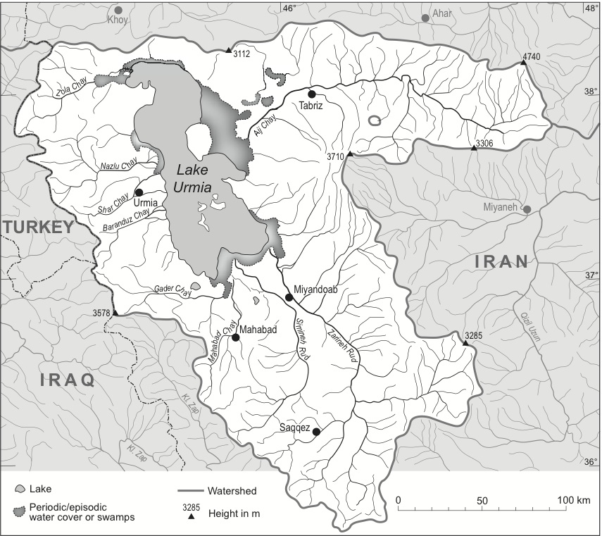
Geographical environment. Fluctuations of the lake’s size and oscillations of its water table are closely connected with the geographical environment of its basin.  Like so many other drainage basins in Iran, Lake Urmia is the center of an internal drainage basin and distinctly separated from other basins by a high mountain environment on all sides.  Size of the drainage basin and, therefore, also of the catchment area of Lake Urmia is about 51.000 km2.  The overall physiography is that of an almost circular geological basin structure with the lake in its central part.  As such, it receives a number of tributaries of different lengths and water-carrying intensities.  The longest of them is the Zarrinarud with a length of approximately 230 km, entering the lake from the south.  The second largest is the Āji Čāy with a length of approximately 140 km.  According to Ghaheri et al. (p. 20), a total of 21 permanent or seasonal rivers as well as 39 periodic ones discharge into the lake (Figure 1).
Permanence, seasonality, and/or periodicity of the tributaries to Lake Urmia are distinctly influenced by both topography and climate.  While most of the rivers have only small catchment areas, separated from each other by eroded crests and ridges (Figure 1), the overall height of the Lake Urmia basin and its surroundings are responsible for the climatic parameters of the basin.  While the basin itself receives less than 300 mm rainfall per year, the surrounding plains and mountain ranges with many heights up to more than 3,200 meters (Figure 1) are covered by heavy winter snowfall, which is the basis of an increased runoff of the lake’s tributaries in spring and early summer.  The overall climate situation of the Lake Urmia basin is characterized by cold winters and long, dry summers.  In winter, the temperature can get as low as -20centigrade or even lower, while in summer it may easily surpass 35o Altogether, the meteorological year of the basin can be separated into a predominantly moist and humid winter season lasting from November to April/May and an arid summer season from May to October.  Average rainfall within the basin has been calculated to be 235 mm (average of the time period 1967-2006), with a distinct decrease by 40 mm for the ten-year period of 1997-2006, a clear indication of climate change and typical for similar findings in northwestern Iran (Pengra, p. 6).
Hydrology.  Topography and climate are decisive factors for the hydrology of Lake Urmia.  Analysis of its annual cycle demonstrates that the beginning of snowmelt in the mountains in late spring leads to increased discharges of the rivers and to rising water levels of the lake.  These annual fluctuations of the lake surface may vary between 20 cm to 50-60 cm in the years of above-average precipitation.  The overall annual inflow into Lake Urmia is considered to be 6,900 million m3 of water, of which 4,900 million m3 are contributed by rivers, 500 million m3 by floods, and 1,500 million m3 by precipitation over the lake (Ghaheri et al., p. 19).  Deviations of these averages cause slightly higher or lower annual levels of the lake surface, and they are also responsible for the fact that a varying number of islands come into existence when the water level is low (Ghaheri et al., p. 20). 
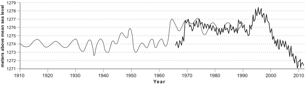
In contrast to the annual fluctuations of the lake surface, long-term variations of the lake are much more dramatic.  They are the causes of heavy ecological concern.  As mentioned already, the secular fluctuations of the lake are considerable (for very rough geological details, see Kaehne, pp. 122-23; Figure 3).  Not taking into account the geological history of the lake, which according to Günther Schweizer is documented by a glacial terrace system as a result of much higher lake levels of 30 m, 60 to 65 m, 80 to 85 m, and 115 m above the water level of 1968 (i.e., 1,280 m), its more recent fluctuations with amplitudes of up to 10 meters are alarming.  They are indicators not only for the hydrological vulnerability of the lake, but in the long term also for the continuous diminution of the body of water and the reduction of the mean (6-8 m) and maximum (13-15 m) depth of the lake (Figure 2).
Reasons for these fluctuations are manifold. While the annual and more or less regular variations are due to the temperature and precipitation regimes of the Lake Urmia basin and its surroundings, the longer-term oscillations must be interpreted as reactions to short-term climate changes:
Because Lake Urmia is a terminal lake with no significant water outflow, the only way water leaves the lake is by evaporation.  Therefore, if the lake declines it is either by increased evaporation or a decrease in water coming into the system.  The Zarrineh Rood River is the largest of the thirteen main rivers discharging into Lake Urmia, which are the source of the majority of the Lake’s water budget.  Additional input comes from rainfall directly over the lake, floodwater from the immediate watershed and a very small fraction from groundwater flow. (Pengra, p. 6)  
According to the same source, 65 percent of the dramatic decline of Lake Urmia in recent years is due to reduced river discharges, decreased precipitation over the lake (10 percent), and construction of dams (25 percent) for irrigation purposes, while the annual evaporation rate of the lake is considered to be about 1 m (Ghaheri et al.).  Evaporation rates, however, cannot be held responsible for the tremendous secular oscillations of this endorheic lake.  As indicated in Figure 2, variations of the lake surface have been observed (although obviously not regularly measured with standard equipment) over the past 100 years (an interesting compilation of sea level fluctuations of Lake Urmia in the 19th century and up to 1914 is recorded by Kaehne, pp. 131-32).  It is fact, however, that within a period of 15 years the surface elevation of the lake dramatically decreased by approximately 7 m from its peak in the mid-1990s (1,278 m above msl) to 1,271 m above msl in 2010.  This dramatic decrease must have dramatic impacts on the salt content of the endorheic lake and, as a result, on the biology of this unique body of water.
Physico-chemical features.  A very specific feature of Lake Urmia is its salinity, typical for many endorheic lakes in arid and semi-arid environments.  In one of the earlier in-depth investigations of Lake Urmia, Heinz Löffler (1956, p. 215) recorded concentrations of 366 grams of salt per liter.  However, these measurements also seem to reflect very special conditions.  Chemical analyses of more recent data indicate lower values.  While 300 g/l almost reaches saturation levels—salt concentrations almost 8 times higher than oceanic sea water—average concentrations of Lake Urmia seem to be 217-35 g/l (Ghaheri et al., p. 20) with sodium and cloride as dominant ions.  Yet, these concentrations vary and are also dependent on the annual water cycle of the lake; the concentrations are lower in spring with higher sweet water discharges of the rivers, and they increase in summer with the sinking water table and higher temperatures and evaporation (Löffler, 1961, pp. 338-45).  Due to the fact that the surrounding mountain ranges of the Lake Urmia basin are characterized also by salt-bearing strata and by volcanoes, both gypsum and salt deposits have been accumulated in the bottom of the lake (Löffler, 1961, p. 339): “The total salt mass is estimated as 12 × 109 tons, most of which has ultimately been derived from river inputs” (Ghaheri et al., p. 20). High evaporation rates over the lake maintain and even increase the salt content, depending on the water table.
Biological and environmental aspects.  The salinity of Lake Urmia and the considerable fluctuations of the lake make it a unique hydrological and ecological phenomenon. While fish populations and mollusks do not exist in this hypersaline environment, Lake Urmia is home of a number of diatoms, phytoplankton (algae). and bacteria (see Löffler, 1956, p. 216; idem, 1961, pp. 340 ff.), while the coastal strips are wetlands of varying extent and partly covered by a salt-tolerant littoral vegetation.  In spite of the overall reduced living conditions for flora and fauna, Lake Urmia provides an important habitat for the aforementioned species.  Löffler (1961, p. 342-45) lists a great number of diatoms, rotatoria, and green algae (esp. Euglena) that constitute the lower end of a food chain in which shrimp populations play a crucial part.  Especially the brine shrimp Artemia urmia is an important food link for migratory birds such as pelicans, flamingos, and different kinds of egrets and ducks.  On the whole it is evident that the intensity of bird migration is dependent on the primary production of the lake and especially on the availability of salt-adjusted brine shrimps.  The increasing salt content of Lake Urmia water is a major threat to the continuation of this highly sensitive food chain.
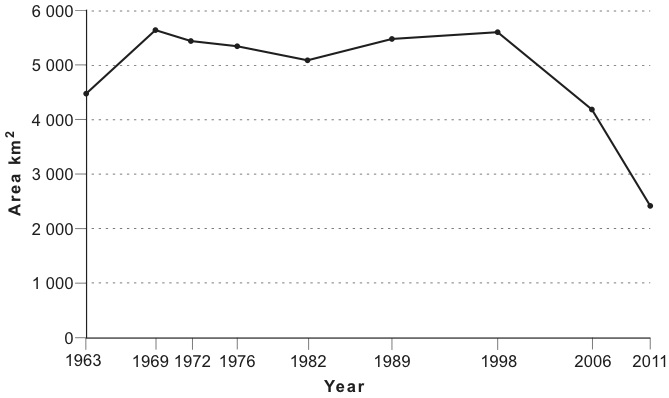
Present state and future of Lake Urmia.  Today, Lake Urmia represents a highly endangered ecosystem, the future of which is being compared to the catastrophic fate of the Aral Sea in Central Asia.  While the present shrinkage of the lake is dramatic, the consequences of this development are even more alarming (for a detailed analysis, see Pengra, figs. 3, 5, and 6 with satellite images from 1963 to 2011; see also Alesheikt et al.).  Reasons for the permanent reduction of the lake surface are, above all, an increasing use of the tributary river waters for irrigation purposes either by diversion of the water directly into the fields or by construction of dams and retention basins.  An immediate consequence of the lake’s retreat is the exposure of increasingly large sections of the former lakebed and their salt crusts to the forces of wind.  At present, more than 400 km2 of sodium chloride-covered salt flats surround the lake and are being blown out.  Wind erosion causes salt storms, and the salty particles are deposited on adjoining agricultural lands, diminishing their fertility and productivity.  Additionally, many rivers are polluted by untreated urban household and industrial waters, causing additional problems both for the ecology of the lake and the human population of its shore regions.  Finally, the construction of a causeway and bridge has added further problems to the hydrology of the lake.  This structure, using the island/peninsula (depending on the height of the water table) of Šāhi (Šebh-e Jazira-ye Šāhi) as a bridgehead, is a major obstacle for the already reduced circulation of water and divides the lake into two parts of almost equal size.  It is interesting to note that before World War I there was a commercial shipping fleet on the waters of Lake Urmia.  Günther (1899, p. 512) reports that “the fleet at present on Lake Urmi consists of three ships of about 20 tons burden, round bottomed, round bowed, but with flat sterns and a great capability of rolling.”  Their efficiency, however, seems to have been rather limited since these sailing boats were heavily dependent on regular and rapidly changing winds.  The consequences of Lake Urmia’s shrinking and potential countermeasures to re-establish its former size are indicated by Pengra (pp. 7-9).  The latter are, however, rather unrealistic (for instance, diversion and pumping of Caspian Sea waters to Lake Urmia).  Instead, construction of water treatment plants along the main rivers and deconstruction of dams, barrages, and water channels in order to restore a natural river flow would be a better option with, however, negative impacts on the agricultural activities in the Lake Urmia basin.
 Figures:


Bibliography
M. Abbaspour,. and A. Nazaridoust,. “Determination of Environmental Water Requirements of Lake Urmia, Iran: An Ecological Approach,” International Journal of Environmental Studies 64/2, 2007, pp. 161-69.
A. A. Alesheikt, A. Ghorbanali, and N. Nouri, “Coastline Change Detection Using Remote Sensing,” International Journal of Environmental Sciences and Technology 4/1, 2007, pp. 61-66.
Samad Alipour, “Hydrogeochemistry of Seasonal Variation of Urmia Salt Lake, Iran,” Saline Systems 2/9, 2006.
Alireza Asem, Fereidun Mohebbi, and Reza Ahmadi, “Drought in Urmia Lake, the Largest Natural Habitat of Brine Shrimp Artemia,” World Aquaculture 43, 2012, pp. 36–38.
Y. Asri, and M. Ghorbanli, “The Halophilous Vegetation of the Orumieh Lake Salt Marshes, NW. Iran,” Plant Ecology, no. 132, 1997, pp. 155-70.
Peter Beaumont, River Regimes in Iran, University of Durham, Deptartment of Geography, Occasional Publications, New Series 1. Durham, 1973.
J. F. Coakley, “Urmia,” in EI2 X, 2000, pp. 896-99.
ʿAbd-al-Raḥmān ʿEmādi, “Nāmhā-ye Daryāča-ye Orumiya,” in Iraj Afšār and Qodrat-Allāh Rowšani Zaʿfarānlu, eds., Yaḡmā-ye si-o dovvom: yādnāma-ye Ḥabib Yaḡmāʾi, Tehran, 1991, pp. 301-9.
Environment Protection Bureau of West Azarbayan Province, A Study for the Establishment of Natural Park on the Islands of Urmia Lake, 3 vols., Tehran, 1992 (in Persian).
Esmāʿil Eʿtemādi, “Kuh-e gusfand (Quyun daḡi dar Daryāča-ye Urmia),” Talāš, no 19, 1969, pp. 74-80.
M. Ghaheri, M. H. Baghal-Vayjooee, and J. Naziri, “Lake Urmia, Iran: A Summary Review,” International Journal of Salt Lake Research 8, 1999, pp. 19-22.
Hossein Golabian, “Urumia Lake: Hydro-Ecological Stabilization and Permanence,” in Viorel Badescu and Richard B. Cathcart, eds., Macro-engineering Seawater in Unique Environments, Berlin, 2011, pp. 365-97.
Robert T. Günther, “Contribution to the Geography of Lake Urmia,” Geographical Journal 14/5, 1899, pp. 504-11.
Idem, “Contribution to the Natural History of Lake Urmia NW Persia and Its Neighborhood,” Journal of the Linnaean Society: Zoology 27, 1900, pp. 345-453.
Robert T. Günther and J. J. Manley, “On the Waters of the Salt of Lake of Urmi,”Proceedings of the Royal Society of London 65, 1899, pp. 312-18.
Mukhtar Hasemi, “A Socio-technical Assessment Framework for Integrated Water Resources Management (IWRM) in Lake Urmia Basin, Iran,” Ph.D. diss., University of Newcastle upon Tyne, 2012.
Sheida Jalili et al., “The Influence of Large-scale Atmospheric Circulation Weather Types on Variations in the Water Level of Lake Urmia, Iran,” International Journal of Climatology 32, 2012, pp. 1990-96.
K. Kaehne, “Beiträge zur physischen Geographie des Urmija-Beckens,” Zeitschrift der Geselschaft für Erdkunde zu Berlin, 1923,  pp. 104-32.
Abdolreza Karbassi et al., “Environmental Impacts of Desalination on the Ecology of Lake Urmia,” Journal of Great Lakes Research 36/3, 2010, pp.  419-24.
Masʿud Kayhān, Joḡrāfiā-ye mofaṣṣal-e Irān, 3 vols., Tehran, 1931-32, I, pp. 80-84.
Guy Le Strange, The Land of the Eastern Caliphate: Mesopotamia, Persia, and Central Asia, Cambridge, 1905; tr. Maḥmud ʿErfān, as Joḡrāfiā-ye tāriḵi-e sarzaminhā-ye ḵelāfat šarqi, Tehran, 1958, pp. 171-72.
Heinz Löffler, “Ergebnisse der Österreichischen Iranexpedition 1949/50: Limnologische Untersuchungen an Iranischen Binnengewässern,” Hydrobiologia8/3-4, 1956, pp. 201-78.
Idem, “Beiträge zur Kenntnis der Iranischen Binnengewässer II: Regional-limnologische Studie mit besonderer Berücksichtigung der Crustaceenfauna,”Internationale Revue der gesamten Hydrobiologie und Hydrographie 46/3, 1961, pp. 309-406 (esp. pp. 338-45, with extensive bibliography).
R. de Mecquenem, “Le lac d’Ourmiah,” Annales de Geographie, 17, 1908, pp. 128-44.
B. Pengra, “The Drying of Iran’s Lake Urmia And Its Environmental Consequences,”UNEP Global Environmental Alert Service (GEAS), February 2012, available at http://na.unep.net/geas/getUNEPPageWithArticleIDScript.php? article_id=79 (accesed 1 February 2013).
ʿEnāyat-Allāh Reżā, “Urmia,” in Dāyerat al-maʿāref-e bozorg-e eslāmi X, pp. 422-24.
Alfred Rodler, Der Urmia-See und das nordwestliche Persien, Wien, 1887, pp. 535-75.
Günther Schweizer, Untersuchungen zur Physiogeographie von Ostanatolien und Nordwestiran. Geomorphologische, klima- und hydrogeographische Studien im Vansee- und Rezaiyehsee-Gebiet, Tübinger Geografische Studien, Heft 60, Tübingen, 1975.
M. Zarghami, “Effective Watershed Management; Case Study of Urmia Lake, Iran,”Lake and Reservoir Management 27/1, 2011, pp. 87-94.
M. Zeinoddini, M., Tofighi, and F., Vafaee, “Evaluation of Dike-type Causeway Impacts on the Flow and Salinity Regimes in Urmia Lake, Iran,” Journal of Great Lakes Research 35/1, 2009, pp. 13-22.
(Eckhart Ehlers)
Originally Published: February 5, 2013
Last Updated: February 5, 2013
Direct link to the cite: http://www.iranicaonline.org/articles/urmia-lake

Cite this entry:
Eckhart Ehlers, “Urmia, Lake,” Encyclopædia Iranica, online edition, 2013, available at http://www.iranicaonline.org/articles/urmia-lake (accessed on 18 April 2016).

Thursday, February 18, 2016

Article: Structural characteristics of annual precipitation in Lake Urmia basin

Hi

At last I got my paper published on the web. It is about patterns of annual precipitation in the basin. You can download it from Springer link.

Structural characteristics of annual precipitation in Lake Urmia basin


The proper citation would be.
Vaheddoost B, Aksoy H (2016) Structural characteristics of annual precipitation in Lake Urmia basin. Theoretical and Applied Climatology (): 1-14, DOI 10.1007/s00704-016-1748-3

Thankfully 
Babak

Tuesday, February 9, 2016

A very old picture of Lake Urmia (Source: Undefined)

Hi,
To day I got an old picture of Lake Urmia from a friend of mine. It is taken in 1920 but unfortunately there is no evidence that who take this picture.

Lake Urmia 1920 (1299 Shamsi-Jalali)

Saturday, February 6, 2016

Lake Urmia, Lake Van & Lake Sevana (Source: NASA Visible Earth)

Hi,

I copied this from the cite NASA Visible Earth. You can see both Lake Van and Urmia by high resolution in it.

  • Credit:  Jacques Descloitres, MODIS Rapid Response Team, NASA/GSFC

Turkey’s largest lake and Iran’s largest lake are both featured in this true-color image, acquired by the Moderate Resolution Imaging Spectroradiometer (MODIS) on NASA’s Terra satellite on September 9, 2003. The deep blue lake on the left is Turkey’ Lake Van. The lake is 120 kilometers long and 80 kilometers wide. It is fed by mountain streams, but has no outlet except evaporation. This has allowed salts and minerals to build in the lake to the point that only one species of fish can survive in its waters.

To the right of Lake Van is Iran’s Lake Urmia. Like Lake Van, Lake Urmia receives water from the surrounding mountains, but has no outlet. Lake Urmia is shallow, and sediment colors its waters turquoise compared to the deep black of Lake Van. North of both lakes is Armenia’s Lake Sevana.


New Paper

Hi everyone

My paper about "Structural characteristics of annual precipitation in Lake Urmia Basin" is accepted in Theoretical and Applied Climatology. I will soon put a link about it and you can download and find out about it. There are a lot of discussion about probabilistic and probability distribution function properties of annual rainfall in it.
I added a iso-entropy map as an innovative part that can be handy to recognize the degree of uncertainty in annual precipitation. It seems that the westerly breezing air fronts have the most influence on the properties of the annual rainfall in the basin. It still affect the regions individually and precipitation is strictly dependent on the terrain.
It is concluded that, annual rainfall in all its distributional properties changes radical from West to the East side of the basin as passing through the Lake Urmia but less in passing from North to South.

Thank you

Thursday, February 4, 2016

Several Photographs by Hossein Mahmoodi

These pictures are dramatic but beautiful.
I think the bigger the disaster is you can expect for bigger influence. It really breaks my heart. I pray for the better future.
Thank you Mr. Mahmoodi for these beautiful pictures!!!


Monday, February 1, 2016

Annual precipitatition in Lake Urmia Basin

Hi

My last article has now accepted to be published at Theoretical and Applied Climatology. It is about structural characteristics of annual rainfall in Lake Urmia basin. I removed some stuff that I want to share it in here.
My study concludes that, North West and South West of the basin have the highest maximum rainfall amount, while the lowest amounts (i.e. Lowest amount related to max. observed annual rainfall) are related to the East coasts of the LU. To some extent it is confident to recognize that, maximum rainfall in the LUB is related to the altitudes and maximum annual rainfall decreases from West to East. Consequently the main input air fronts of basin are feeding form West and North. Figure 1 shows that the most amount of the vapor and moisture that coming from Turkey toward the LUB is descended inside the Turkish territory (Landsat 4, 5 and 8. USGS, 2015). Minimum amount of rainfall have same pattern while crossing West to East and North West of LUB has the highest min. annual rainfall while the least amounts belongs to Eastern side.

Fig.1. Landsat (4, 5 and 8) views of the West of the basin in the boarder of Turkey and Iran indicating the impact of border’s altitudes on the amount snow available on the land surface. (a) Landsat 4-5. Dec 9, 1987. (b) Landsat 4&5. Feb 4, 2000. (c) Landsat 4&5. May 14, 2007. (d) Landsat 8. Jan 12, 2015. (USGS, 2015)
P.S: please cite the weblog if you want to use this figure in another document

This is first evidence in its own category. Native people believe that Turkish side of the border got more precipitation and this Landsat pictures shows the evidence of such phenomena. Some of my friends believe that the tectonic movements which caused disastrous earthquake at Van (Turky)  in October 2011 is caused in the changes in the terrain which triggered the amount of water vapor crossing the border. 
As a proof they mention that, there were more snow or rain descend in the region but we got a little now a days. This satellite imagery obviously shows the effect of the border's mountains but those not necessarily support the idea of boycotting the air fronts from reaching the inner plains of the basin.

Please share your idea with me
Thankfully
Babak 

Monday, January 25, 2016

Water Level raised up to 36 cm (Source: Lake Urmia Rescue Campaign, Telegram Channel)

Hi every one

The latest pictures show that the water level is raised by at least 36 cm in Lake Urmia and coastal waves are observed once again on the water body. It is heart warming and I am still praying for the Lake. Too sad for me, cause once it was one of the main aspects and features of my home town. I spent my childhood swimming in this lake and now my heart is broken when I am looking at the seen. May god help us saving the lake, Amen!!


Monday, January 18, 2016

Groundwater time series

Hey guys

After being done with Runoff time series, it is inevitable challenge the groundwater time series. As I mentioned before (123), I think coastal aquifers have very significant affect on the lake itself. Their flux to the lake or even the salinity intrusion from lake to the aquifer are the consequences of this interaction.
Most of the researchers used to handle this interaction with Darcy's law (Darcy, 1856), while others try to control it by the chemical components that transfers between lake and aquifer. Such methods are useless for me cause I don't have any observation data on chemical components and/or hydraulic conductivity between lake and aquifers. Thus, I tried to solve it by simplifying the problem.
Figure 1 shows the potential elevation of the aquifer in comparison with lake water level. As a potential depth of influx/drainage it can be used as the potential depth which would affect the lake surface at most correlated wells near the shore line or from underneath.
Fig.1. Schematic of potential influx/outflow between lake and coastal aquifers
For this, in the first place an iso-correlation map between lake and coastal aquifer will be generated. In the next stage an iso-correlation map with different lag times (Cross-correlation) will be investigated also. Then, proper wells (i.e. most correlated ones) will be selected and iso-height maps of water level in aquifers will be recognized. Then the potential depth between lake and aquifer will be calculated by subtracting the Lake water level from wells' water level.
This values could be positive or negative which defines the availability of GW in flux/draining the lake, which would be very handy in my calculation. In addition, I will not loose site of depth while using a semi-water budget or mass balance equation while all variables have dimensions in length.

Please do not hesitate to share your point of view with me
Babak


Thursday, January 14, 2016

Lake Urmia: how Iran’s most famous lake is disappearing (Source: The Guardian)


By: Ali Mirchi, Kaveh Madani and Amir AghaKouchak for Tehran Bureau

New research shows Iran’s most famous lake has shrunk by nearly 90% since the 1970s. Scientists urge action


Lake Urmia in Iran on 8 August 2010 Photograph: Alessandro Marongiu / Demotix/Alessandro Marongiu / Demotix/Demotix/Corbis


In the late 1990s, Lake Urmia, in north-western Iran, was twice as large as Luxembourg and the largest salt-water lake in the Middle East. Since then it has shrunk substantially, and was sliced in half in 2008, with consequences uncertain to this day, by a 15-km causeway designed to shorten the travel time between the cities of Urmia and Tabriz.


Historically, the lake attracted migratory birds including flamingos, pelicans, ducks and egrets. Its drying up, or desiccation, is undermining the local food web, especially by destroying one of the world’s largest natural habitats of the brine shrimp Artemia, a hardy species that can tolerate salinity levels of 340 grams per litre, more than eight times saltier than ocean water.

Effects on humans are perhaps even more complicated. The tourism sector has clearly lost out. While the lake once attracted visitors from near and far, some believing in its therapeutic properties, Urmia has turned into a vast salt-white barren land with beached boats serving as a striking image of what the future may hold.
FacebookTwitterPinterest Lake Urmia Photograph: Kaveh Madani

Desiccation will increase the frequency of salt storms that sweep across the exposed lakebed, diminishing the productivity of surrounding agricultural lands and encouraging farmers to move away. Poor air, land, and water quality all haveserious health effects including respiratory and eye diseases .

The people of the north west – mainly Azeris and Kurds – are raising their voices. The Azeris, one of Iran’s most influential ethnic groups and about a third of the country’s population, venerate Urmia as a symbol of Azeri identity, dubbing it “the turquoise solitaire of Azerbaijan”. The region is also home to many Kurds, who are demanding a bigger say in the management of the lake to improve the livelihood of Kurdish communities.

President Hassan Rouhani has shown he is listening, referring to Urmia during his election campaign, and subsequently promising the equivalent of $5 billion to help revive the lake over ten years. Solutions, however, require agreement on the main causes of the problem, and this motivated a group of concerned Iranian researchers in the United States, Canada, and United Kingdom to carry out an independent, first-hand assessment beginning in 2013. Because of the unavailability of reliable and consistent ground-truth data, the team used high-resolution satellite observations over the past four decades to estimate the lake’s physiographic changes.


Lake Urmia, Iran 1972-2014

The results of this investigation, which recently appeared in the Journal of Great Lakes Research, revealed that in September 2014 the lake’s surface area was about 12% of its average size in the 1970s, a far bigger fall than previously realised. The research undermines any notion of a crisis caused primarily by climate changes. It shows that the pattern of droughts in the region has not changed significantly, and that Lake Urmia survived more severe droughts in the past.

The lake’s surface area naturally varies to some extent between wet and dry seasons and the situation has eased somewhat with seasonal precipitation that occurred since September. But the magnitude and timeline of the shrinkage ­– frequently attributed by the Iranian water authorities to years of below-average precipitation – are unquestionably beyond the ordinary, and suggest that the lake may have reached a “tipping point” leading to sudden death. If Lake Urmia is to be revived, the authorities must look urgently at the construction of dams and irrigation projects designed to boost agri-business and meet growing regional water demand.


The tragic demise of the Aral Sea in central Asia is a chilling precedent. Once one of the world’s largest lakes, the Aral Sea faded away due to diversion of water for agriculture from its tributaries, the Amu Darya and Syr Darya rivers. The Aral Sea became a hallmark of poor agricultural water management in the Soviet era. Over the course of five decades its surface area dropped to less than 10% of its original extent in the 1960s

It is ironic that the collapse of Lake Urmia and other Iranian water bodies such as Shadegan, Gav-Khuni, Bakhtegan, Anzali, and Hamouns comes in the country where the 1971 Ramsar Convention was signed. As a pioneering intergovernmental treaty for conservation and sustainable use of wetlands, Ramsar envisaged action by both national governments and international co-operation.

Just five years later, in 1976, UNESCO (the United Nations Educational, Scientific and Cultural Organisation) designated Lake Urmia a biosphere reserve toencourage sustainable development grounded in community involvement and sound science.

Given the far-reaching socio-economic effects, and human health impacts that may extend beyond Iran’s borders, Lake Urmia’s collapse requires active involvement of international organisations that can provide expertise and financial resources, even if their efforts to help are complicated by sanctions blocking financial transactions. These include UNESCO, the United NationsDevelopment Programme (UNDP), the Global Environment Facility (GEF), the World Bank, World Climate Research Programme (WCRP), European Commission Joint Research Centre (JRC) and World Health Organization (WHO).

FacebookTwitterPinterest Lake Urmia Photograph: Kaveh Madani

On the bright side, growing public awareness about water scarcity, mismanagement and waste may pave the way for re-establishing a balance between natural water supply and water demand. The three provinces that share the Lake Urmia basin - East Azerbaijan, West Azerbaijan, and Kurdistan - and the Iranian government have joined forces to devise promising restoration ideas, including stopping dam construction, managing the existing reservoirs and regulating the use of the agricultural lands. Such changes could augment the lake’s inflow, limit additional surface water and groundwater withdrawal, and mitigate salt blowouts and sand storms.
Advertisement


However, this is barely enough for any realistic optimism. Demand-side management plans to reduce the basin’s water use must go in effect immediately, and proposals for water transfer - which have had harmful ecological and socio-economic side-effects in other parts of Iran - need drastic revision. There is an obvious need, too, for schemes to compensate current water-users for any losses.

While international help is important, Iranians must lead restoration efforts, for Lake Urmia and other water bodies. Iran’s push for development is taking a toll on the nation’s water resources in a mostly arid and semi-arid country as short-sighted projects transfer water to supply inefficient agriculture and growing urban areas. Without a pragmatic action plan, the country faces severe water stress.

The authors were all involved in the independent investigation of Lake Urmia. Ali Mirchi is a postdoctoral research associate at the Department of Civil and Environmental Engineering, Michigan Technological University; Kaveh Madani is a lecturer in Environmental Management at the Centre for Environmental Policy, Imperial College London; Amir AghaKouchak is an assistant professor at the Department of Civil and Environmental Engineering, University of California, Irvine

Interaction of coastal aquifer and lake water level

Hi,
Tomorrow is my 3rd thesis report day. I am now finished with the presentation and I just started to do analysis on groundwater.
In the first place, I started with Pearson correlation coefficient. Result are very interesting, as I mentioned before, there is a strong evidence that groundwater and lake have strong relations. Accounting for a probable cross-correlation lag between lake and ground water, it sounds like interaction between these two are inevitable. AS you can see in Fig.1 Pearson correlation coefficient in West bank of the Lake is negative while positive correlations are observed in the East bank of the lake.


Fig.1. Iso-correlation map of the Lake Urmia, defining the negative correlation coefficient for the West (Left) and positive correlation for the East (Right) bank

This values some how make sense while, the incline of the terrain in the West bank is more rapid and sharp. Fig. 2 shows a schematic representation of geological features in the Lake Urmia. In the West bank of the lake, groundwater elevation changes in reverse order with the lake and decreases when the lake water level increase. On the other hand, in East bank, lake water level and ground water elevation changes in the same way. This could be an evidence to recognize that, salinity intrusion is more severe in the East bank of the lake (East Azerbaijan) while the West bank plays more active role in interaction.

Fig. 2. Schematic of lake Urmia and the possible interaction between lake and coastal aquifer

Please share your comments with me
Thankfully
Babak

Monday, January 11, 2016

New Satellite Views of LU

The latest satellite view of Lake Urmia (Source: Campaign on Lake Urmia Rescue Telegram Channel).

Fig. 1. Nasa Aqua satellite view of Lake Urmia and remaining water in the North of the Lake (Dec 21, 2015)

Fig. 2. LandSat image about the project of linking Zarrine and Simine River in the South of lake as one of the main rescue projects (November 21, 2015)

Thursday, December 17, 2015

Diagram for Height-Area-Volume of the Lake

I recently got some good data about water level, area and volume of the lake. So I now introducing a new diagram named "Height-Area-Volume" for Lake Urmia.
I hope This will help!
Height-Area-Volume diagram of Lake Urmia