Showing posts with label Information. Show all posts

Tuesday, August 2, 2016

Lithology of groundwater in Lake Urmia

Hi everyone,
since my last post I have a major break through in my thesis. So I will try to share some of them with you in near future. No I am going through for clearing some issues about groundwater flow.
Now I am sharing a map which can be helpful for those whom want to get an idea about the Lithology of lake Urmia.


Saturday, May 28, 2016

Encyclopedia Iranica: Urmia, Lake

Urmia, Lake

Fluctuations of Lake Urmia’s size and oscillations of its water table are closely connected with the geographical environment of its basin.  Like so many other drainage basins in Iran, Lake Urmia is the center of an internal drainage basin and distinctly separated from other basins by a high mountain environment on all sides. 
Urmia, Lake, called Lake (Daryāča-ye) Reżāʾiya in the Pahlavi period, a salt lake in northwest Iran separating the provinces of West Azerbaijan (Aḏarbāyjan-e Ḡarbi) and East Azerbaijan (Aḏarbāyjan-e Šarqi). Lake Urmia is the largest lake in the Middle East and the second largest salt lake on earth.  It is located 4,183 feet above sea level, lat 37o to 38.5N, long 45o to 46E.  It is approximately 140 km long in a north-south direction and about 85 km wide in its east-west extension with a surface area of 5,000 to 6,000 km2.  Depending on the time of observation and measurement, the height of the water table varies between 1,295 m. above mean sea level (msl; Löffler, 1956, p. 214 [probably an incorrect measurement]) to 1,280 m. (Schweizer) and 1,271 m. above sea level (Pengra).  Earlier, though necessarily rough, measurements substantiate these observations.  While Robert Güthner (1899, p. 505) speaks of an overall basin size of “19.370 square miles, of which 1795 square miles are at present occupied by the Lake of Urmi and its Islands” (that is, 50,168 km2 and 4,649 km2 respectively), de Macquenem (p. 129) speaks of only a 35,000 km2 basin size.  Kaehne (p. 104), on the other hand, calculates an overall size of the Lake Urmia catchment area of approximately 52,500 km2, of more than 13,000 km2 for the immediate lake basin, and of 5,775 km2 for Lake Urmia itself.  All these figures indicate the lake’s great fluctuations in time and space and its constantly changing size and depth, which is also responsible for the variations of its salt content and biogeochemistry.
Geographical environment. Fluctuations of the lake’s size and oscillations of its water table are closely connected with the geographical environment of its basin.  Like so many other drainage basins in Iran, Lake Urmia is the center of an internal drainage basin and distinctly separated from other basins by a high mountain environment on all sides.  Size of the drainage basin and, therefore, also of the catchment area of Lake Urmia is about 51.000 km
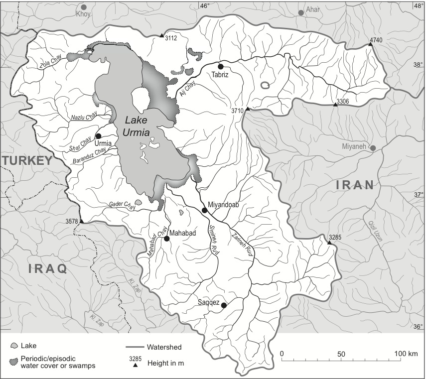
2.  The overall physiography is that of an almost circular geological basin structure with the lake in its central part.  As such, it receives a number of tributaries of different lengths and water-carrying intensities.  The longest of them is the Zarrinarud with a length of approximately 230 km, entering the lake from the south.  The second largest is the Āji Čāy with a length of approximately 140 km.  According to Ghaheri et al. (p. 20), a total of 21 permanent or seasonal rivers as well as 39 periodic ones discharge into the lake (Figure 1).
Permanence, seasonality, and/or periodicity of the tributaries to Lake Urmia are distinctly influenced by both topography and climate.  While most of the rivers have only small catchment areas, separated from each other by eroded crests and ridges (Figure 1), the overall height of the Lake Urmia basin and its surroundings are responsible for the climatic parameters of the basin.  While the basin itself receives less than 300 mm rainfall per year, the surrounding plains and mountain ranges with many heights up to more than 3,200 meters (Figure 1) are covered by heavy winter snowfall, which is the basis of an increased runoff of the lake’s tributaries in spring and early summer.  The overall climate situation of the Lake Urmia basin is characterized by cold winters and long, dry summers.  In winter, the temperature can get as low as -20centigrade or even lower, while in summer it may easily surpass 35o Altogether, the meteorological year of the basin can be separated into a predominantly moist and humid winter season lasting from November to April/May and an arid summer season from May to October.  Average rainfall within the basin has been calculated to be 235 mm (average of the time period 1967-2006), with a distinct decrease by 40 mm for the ten-year period of 1997-2006, a clear indication of climate change and typical for similar findings in northwestern Iran (Pengra, p. 6).
Hydrology.  Topography and climate are decisive factors for the hydrology of Lake Urmia.  Analysis of its annual cycle demonstrates that the beginning of snowmelt in the mountains in late spring leads to increased discharges of the rivers and to rising water levels of the lake.  These annual fluctuations of the lake surface may vary between 20 cm to 50-60 cm in the years of above-average precipitation.  The overall annual inflow into Lake Urmia is considered to be 6,900 million m3 of water, of which 4,900 million m3 are contributed by rivers, 500 million m3 by floods, and 1,500 million m3 by precipitation over the lake (Ghaheri et al., p. 19).  Deviations of these averages cause slightly higher or lower annual levels of the lake surface, and they are also responsible for the fact that a varying number of islands come into existence when the water level is low (Ghaheri et al., p. 20). 
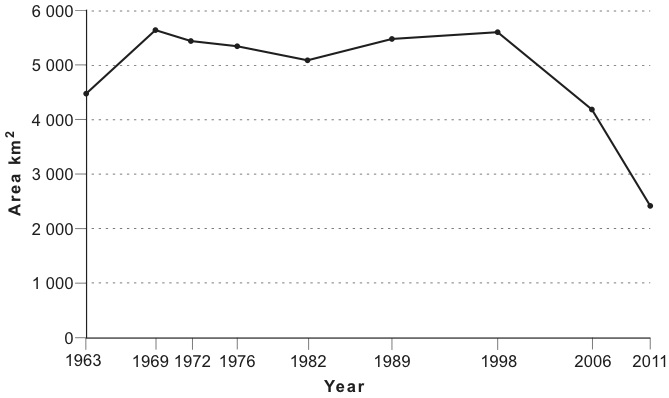
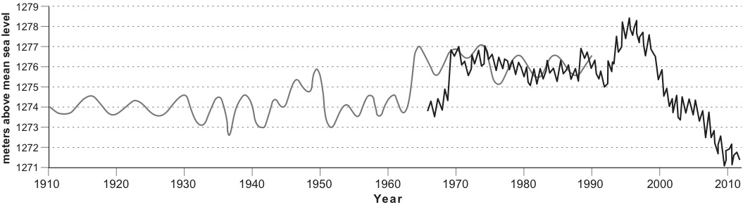
In contrast to the annual fluctuations of the lake surface, long-term variations of the lake are much more dramatic.  They are the causes of heavy ecological concern.  As mentioned already, the secular fluctuations of the lake are considerable (for very rough geological details, see Kaehne, pp. 122-23; Figure 3).  Not taking into account the geological history of the lake, which according to Günther Schweizer is documented by a glacial terrace system as a result of much higher lake levels of 30 m, 60 to 65 m, 80 to 85 m, and 115 m above the water level of 1968 (i.e., 1,280 m), its more recent fluctuations with amplitudes of up to 10 meters are alarming.  They are indicators not only for the hydrological vulnerability of the lake, but in the long term also for the continuous diminution of the body of water and the reduction of the mean (6-8 m) and maximum (13-15 m) depth of the lake (Figure 2).
Reasons for these fluctuations are manifold. While the annual and more or less regular variations are due to the temperature and precipitation regimes of the Lake Urmia basin and its surroundings, the longer-term oscillations must be interpreted as reactions to short-term climate changes:
Because Lake Urmia is a terminal lake with no significant water outflow, the only way water leaves the lake is by evaporation.  Therefore, if the lake declines it is either by increased evaporation or a decrease in water coming into the system.  The Zarrineh Rood River is the largest of the thirteen main rivers discharging into Lake Urmia, which are the source of the majority of the Lake’s water budget.  Additional input comes from rainfall directly over the lake, floodwater from the immediate watershed and a very small fraction from groundwater flow. (Pengra, p. 6)  
According to the same source, 65 percent of the dramatic decline of Lake Urmia in recent years is due to reduced river discharges, decreased precipitation over the lake (10 percent), and construction of dams (25 percent) for irrigation purposes, while the annual evaporation rate of the lake is considered to be about 1 m (Ghaheri et al.).  Evaporation rates, however, cannot be held responsible for the tremendous secular oscillations of this endorheic lake.  As indicated in Figure 2, variations of the lake surface have been observed (although obviously not regularly measured with standard equipment) over the past 100 years (an interesting compilation of sea level fluctuations of Lake Urmia in the 19th century and up to 1914 is recorded by Kaehne, pp. 131-32).  It is fact, however, that within a period of 15 years the surface elevation of the lake dramatically decreased by approximately 7 m from its peak in the mid-1990s (1,278 m above msl) to 1,271 m above msl in 2010.  This dramatic decrease must have dramatic impacts on the salt content of the endorheic lake and, as a result, on the biology of this unique body of water.
Physico-chemical features.  A very specific feature of Lake Urmia is its salinity, typical for many endorheic lakes in arid and semi-arid environments.  In one of the earlier in-depth investigations of Lake Urmia, Heinz Löffler (1956, p. 215) recorded concentrations of 366 grams of salt per liter.  However, these measurements also seem to reflect very special conditions.  Chemical analyses of more recent data indicate lower values.  While 300 g/l almost reaches saturation levels—salt concentrations almost 8 times higher than oceanic sea water—average concentrations of Lake Urmia seem to be 217-35 g/l (Ghaheri et al., p. 20) with sodium and cloride as dominant ions.  Yet, these concentrations vary and are also dependent on the annual water cycle of the lake; the concentrations are lower in spring with higher sweet water discharges of the rivers, and they increase in summer with the sinking water table and higher temperatures and evaporation (Löffler, 1961, pp. 338-45).  Due to the fact that the surrounding mountain ranges of the Lake Urmia basin are characterized also by salt-bearing strata and by volcanoes, both gypsum and salt deposits have been accumulated in the bottom of the lake (Löffler, 1961, p. 339): “The total salt mass is estimated as 12 × 109 tons, most of which has ultimately been derived from river inputs” (Ghaheri et al., p. 20). High evaporation rates over the lake maintain and even increase the salt content, depending on the water table.
Biological and environmental aspects.  The salinity of Lake Urmia and the considerable fluctuations of the lake make it a unique hydrological and ecological phenomenon. While fish populations and mollusks do not exist in this hypersaline environment, Lake Urmia is home of a number of diatoms, phytoplankton (algae). and bacteria (see Löffler, 1956, p. 216; idem, 1961, pp. 340 ff.), while the coastal strips are wetlands of varying extent and partly covered by a salt-tolerant littoral vegetation.  In spite of the overall reduced living conditions for flora and fauna, Lake Urmia provides an important habitat for the aforementioned species.  Löffler (1961, p. 342-45) lists a great number of diatoms, rotatoria, and green algae (esp. Euglena) that constitute the lower end of a food chain in which shrimp populations play a crucial part.  Especially the brine shrimp Artemia urmia is an important food link for migratory birds such as pelicans, flamingos, and different kinds of egrets and ducks.  On the whole it is evident that the intensity of bird migration is dependent on the primary production of the lake and especially on the availability of salt-adjusted brine shrimps.  The increasing salt content of Lake Urmia water is a major threat to the continuation of this highly sensitive food chain.
Present state and future of Lake Urmia.  Today, Lake Urmia represents a highly endangered ecosystem, the future of which is being compared to the catastrophic fate of the Aral Sea in Central Asia.  While the present shrinkage of the lake is dramatic, the consequences of this development are even more alarming (for a detailed analysis, see Pengra, figs. 3, 5, and 6 with satellite images from 1963 to 2011; see also Alesheikt et al.).  Reasons for the permanent reduction of the lake surface are, above all, an increasing use of the tributary river waters for irrigation purposes either by diversion of the water directly into the fields or by construction of dams and retention basins.  An immediate consequence of the lake’s retreat is the exposure of increasingly large sections of the former lakebed and their salt crusts to the forces of wind.  At present, more than 400 km2 of sodium chloride-covered salt flats surround the lake and are being blown out.  Wind erosion causes salt storms, and the salty particles are deposited on adjoining agricultural lands, diminishing their fertility and productivity.  Additionally, many rivers are polluted by untreated urban household and industrial waters, causing additional problems both for the ecology of the lake and the human population of its shore regions.  Finally, the construction of a causeway and bridge has added further problems to the hydrology of the lake.  This structure, using the island/peninsula (depending on the height of the water table) of Šāhi (Šebh-e Jazira-ye Šāhi) as a bridgehead, is a major obstacle for the already reduced circulation of water and divides the lake into two parts of almost equal size.  It is interesting to note that before World War I there was a commercial shipping fleet on the waters of Lake Urmia.  Günther (1899, p. 512) reports that “the fleet at present on Lake Urmi consists of three ships of about 20 tons burden, round bottomed, round bowed, but with flat sterns and a great capability of rolling.”  Their efficiency, however, seems to have been rather limited since these sailing boats were heavily dependent on regular and rapidly changing winds.  The consequences of Lake Urmia’s shrinking and potential countermeasures to re-establish its former size are indicated by Pengra (pp. 7-9).  The latter are, however, rather unrealistic (for instance, diversion and pumping of Caspian Sea waters to Lake Urmia).  Instead, construction of water treatment plants along the main rivers and deconstruction of dams, barrages, and water channels in order to restore a natural river flow would be a better option with, however, negative impacts on the agricultural activities in the Lake Urmia basin.
 Figures:


Bibliography
M. Abbaspour,. and A. Nazaridoust,. “Determination of Environmental Water Requirements of Lake Urmia, Iran: An Ecological Approach,” International Journal of Environmental Studies 64/2, 2007, pp. 161-69.
A. A. Alesheikt, A. Ghorbanali, and N. Nouri, “Coastline Change Detection Using Remote Sensing,” International Journal of Environmental Sciences and Technology 4/1, 2007, pp. 61-66.
Samad Alipour, “Hydrogeochemistry of Seasonal Variation of Urmia Salt Lake, Iran,” Saline Systems 2/9, 2006.
Alireza Asem, Fereidun Mohebbi, and Reza Ahmadi, “Drought in Urmia Lake, the Largest Natural Habitat of Brine Shrimp Artemia,” World Aquaculture 43, 2012, pp. 36–38.
Y. Asri, and M. Ghorbanli, “The Halophilous Vegetation of the Orumieh Lake Salt Marshes, NW. Iran,” Plant Ecology, no. 132, 1997, pp. 155-70.
Peter Beaumont, River Regimes in Iran, University of Durham, Deptartment of Geography, Occasional Publications, New Series 1. Durham, 1973.
J. F. Coakley, “Urmia,” in EI2 X, 2000, pp. 896-99.
ʿAbd-al-Raḥmān ʿEmādi, “Nāmhā-ye Daryāča-ye Orumiya,” in Iraj Afšār and Qodrat-Allāh Rowšani Zaʿfarānlu, eds., Yaḡmā-ye si-o dovvom: yādnāma-ye Ḥabib Yaḡmāʾi, Tehran, 1991, pp. 301-9.
Environment Protection Bureau of West Azarbayan Province, A Study for the Establishment of Natural Park on the Islands of Urmia Lake, 3 vols., Tehran, 1992 (in Persian).
Esmāʿil Eʿtemādi, “Kuh-e gusfand (Quyun daḡi dar Daryāča-ye Urmia),” Talāš, no 19, 1969, pp. 74-80.
M. Ghaheri, M. H. Baghal-Vayjooee, and J. Naziri, “Lake Urmia, Iran: A Summary Review,” International Journal of Salt Lake Research 8, 1999, pp. 19-22.
Hossein Golabian, “Urumia Lake: Hydro-Ecological Stabilization and Permanence,” in Viorel Badescu and Richard B. Cathcart, eds., Macro-engineering Seawater in Unique Environments, Berlin, 2011, pp. 365-97.
Robert T. Günther, “Contribution to the Geography of Lake Urmia,” Geographical Journal 14/5, 1899, pp. 504-11.
Idem, “Contribution to the Natural History of Lake Urmia NW Persia and Its Neighborhood,” Journal of the Linnaean Society: Zoology 27, 1900, pp. 345-453.
Robert T. Günther and J. J. Manley, “On the Waters of the Salt of Lake of Urmi,”Proceedings of the Royal Society of London 65, 1899, pp. 312-18.
Mukhtar Hasemi, “A Socio-technical Assessment Framework for Integrated Water Resources Management (IWRM) in Lake Urmia Basin, Iran,” Ph.D. diss., University of Newcastle upon Tyne, 2012.
Sheida Jalili et al., “The Influence of Large-scale Atmospheric Circulation Weather Types on Variations in the Water Level of Lake Urmia, Iran,” International Journal of Climatology 32, 2012, pp. 1990-96.
K. Kaehne, “Beiträge zur physischen Geographie des Urmija-Beckens,” Zeitschrift der Geselschaft für Erdkunde zu Berlin, 1923,  pp. 104-32.
Abdolreza Karbassi et al., “Environmental Impacts of Desalination on the Ecology of Lake Urmia,” Journal of Great Lakes Research 36/3, 2010, pp.  419-24.
Masʿud Kayhān, Joḡrāfiā-ye mofaṣṣal-e Irān, 3 vols., Tehran, 1931-32, I, pp. 80-84.
Guy Le Strange, The Land of the Eastern Caliphate: Mesopotamia, Persia, and Central Asia, Cambridge, 1905; tr. Maḥmud ʿErfān, as Joḡrāfiā-ye tāriḵi-e sarzaminhā-ye ḵelāfat šarqi, Tehran, 1958, pp. 171-72.
Heinz Löffler, “Ergebnisse der Österreichischen Iranexpedition 1949/50: Limnologische Untersuchungen an Iranischen Binnengewässern,” Hydrobiologia8/3-4, 1956, pp. 201-78.
Idem, “Beiträge zur Kenntnis der Iranischen Binnengewässer II: Regional-limnologische Studie mit besonderer Berücksichtigung der Crustaceenfauna,”Internationale Revue der gesamten Hydrobiologie und Hydrographie 46/3, 1961, pp. 309-406 (esp. pp. 338-45, with extensive bibliography).
R. de Mecquenem, “Le lac d’Ourmiah,” Annales de Geographie, 17, 1908, pp. 128-44.
B. Pengra, “The Drying of Iran’s Lake Urmia And Its Environmental Consequences,”UNEP Global Environmental Alert Service (GEAS), February 2012, available at http://na.unep.net/geas/getUNEPPageWithArticleIDScript.php? article_id=79 (accesed 1 February 2013).
ʿEnāyat-Allāh Reżā, “Urmia,” in Dāyerat al-maʿāref-e bozorg-e eslāmi X, pp. 422-24.
Alfred Rodler, Der Urmia-See und das nordwestliche Persien, Wien, 1887, pp. 535-75.
Günther Schweizer, Untersuchungen zur Physiogeographie von Ostanatolien und Nordwestiran. Geomorphologische, klima- und hydrogeographische Studien im Vansee- und Rezaiyehsee-Gebiet, Tübinger Geografische Studien, Heft 60, Tübingen, 1975.
M. Zarghami, “Effective Watershed Management; Case Study of Urmia Lake, Iran,”Lake and Reservoir Management 27/1, 2011, pp. 87-94.
M. Zeinoddini, M., Tofighi, and F., Vafaee, “Evaluation of Dike-type Causeway Impacts on the Flow and Salinity Regimes in Urmia Lake, Iran,” Journal of Great Lakes Research 35/1, 2009, pp. 13-22.
(Eckhart Ehlers)
Originally Published: February 5, 2013
Last Updated: February 5, 2013
Direct link to the cite: http://www.iranicaonline.org/articles/urmia-lake

Cite this entry:
Eckhart Ehlers, “Urmia, Lake,” Encyclopædia Iranica, online edition, 2013, available at http://www.iranicaonline.org/articles/urmia-lake (accessed on 18 April 2016).

Saturday, December 26, 2015

Data generation

Hi
Recently, I used to reconstruct some missing data in my runoff and lake water depth time series to fulfill the gaps in the records. For this, I used Frequency Domain Analysis (FDA) combined with Auto Regressive models to catch the remaining information (persistence) in the FDA residual.

  • Firstly a primary set of data is considered with at least 100 month length in order to reproduce the main properties of the generated time series, moments of the distribution and time dependency.
  • In the second stage, time series of data is transformed to Normal distribution and controlled for stationary. The transformation procedure for runoff time series is done with log-transformation, while lake water level time series is manipulated by means of Box-Cox transformation.
  • Then, analysis of spikes in line spectrum (LS) of the model is calculated for catching the main periodicity in the sets. For instance LS of runoff in Simine River is shown in Fig.1.
Fig.1. LLS of Simine River
  • Due to statistical inconsistency of spikes in line spectrum function, a Tukey window is used to transform it to power spectrum (PS) and use the statistically significant spikes in the PS (Fig. 2).
Fig. 2. PS of Simine River
    • Then residual series of the selected Fourier series is calculated and controlled for being a white noise. If there was a remaining information in the procedure an AR model is used for manipulation. Later a normally distributed random series by mean zero and the same standard deviation with residual series is generated.
    • Fig. 3. shows some Fourier series used in Analysis.
    Fig. 3. Fourier series used in Analysis of Simine River
    •  Then after, estimation time series is calculated using selected Fourier series plus random series and controlled for degree of accuracy in comparison with selected transformed time series.
    • Flowingly, selected Fourier series with the most adequate properties is used in manipulations and filling up gaps between data but original data was not disturbed at all.
    • At last, generated time series was tested for statistical properties compared to primary time series. Fig. 3 shows some Fourier series of Simine river.
    • A competitive results of primary and generated tiem series is shown in Table 1 and Fig. 4. The goal is to catch more information and transfer it to the final time series.
    Add caption
    Table. 1. Statistics related to primary and generated time series (Fourier and combined Fourier and AR)
    • Thus, for this case a combined Fourier and AR model is used for generating data. This issue is also used for other time series of runoff and lake water depth.
    Thankfully yours
    Babak


    Wednesday, July 8, 2015

    Can Water Diplomacy Enable a New Future for the Urmia Lake?

    A two-day workshop on a case study using the Water Diplomacy Framework. July 02-03, 2015 at Tufts University and MIT.

    There was an ongoing workshop and webinar in TUFTS and MIT about the Lake and several investigators and research makers were evolved. I completely forgot to put the link here for those whom are interested to follow the debate.
    Anyway, I am putting some links and picture here about the webinar.

    Participants:


    He received a PhD in hydrogeology from University College London, 1991. He has over two decades of consulting, training and research experiences in groundwater modeling and management, hydrogeochemistry, groundwater contamination and groundwater in fractured rocks. Now, he is Dean of Natural Sciences Faculty in University of Tabriz (Iran).

    Shafiqul (“Shafik”) Islam is Professor of Civil and Environmental Engineering and Professor of Water Diplomacy at the Fletcher School of Law and Diplomacy at Tufts. He was the first Bernard M. Gordon Senior Faculty Fellow in Engineering at Tufts University. Professor Islam’s teaching and research interests are to understand characterize, measure, and model water issues ranging from climate to cholera to water diplomacy with a focus on scale issues and remote sensing. His research group WE REASoN integrates “theory and practice” and “think and do” to create actionable water knowledge. Read more.

    Dr. Razyeh Lak
    She is assistant professor of Research Institute for Earth Sciences, Geological Survey of Iran. Her work experience includes manager of Urmia Lake Restoration Program in the field of geology, president of geoscience and vice president of oceanography committees of the Iranian National Commission for UNESCO.

    Prof. Saeed Morid
    Saeed Morid has over two decades of consulting, training and research experiences in different aspects of water resources management. Presently, he is a faculty member in Tarbiat Modares University (Iran). The main fields of his work are drought, climate change and integrated modeling of water resources systems.
    Prof. James Wescoat
    His research has concentrated on water systems in South Asia and the US from the site to river basin scales. For the greater part of his career, Professor Wescoat has focused on small-scale historical waterworks of Mughal gardens and cities in India and Pakistan. He led the Smithsonian Institution’s project titled, “Garden, City, and Empire: The Historical Geography of Mughal Lahore,” which resulted in a co-edited volume on Mughal Gardens: Sources, Places, Representations, Prospects, and The Mughal Garden: Interpretation, Conservation, and Implications with colleagues from the University of Engineering and Technology-Lahore. These and related books have won awards from the Government of Pakistan and Punjab Government.

    Dr. Kamran Zeynalzadeh

    As director of Urmia Lake Research Institute (Urmia University, Iran) my research focuses on study and evaluation of irrigation and drainage systems, environmental studies, On-farm water management and catchment area, percolation and leakage in soils.

    Speakers (Online)

    Dr. Hamed Ghoddusi
    Hamed Ghoddusi is an Assistant Professor at the School of Business, Stevens Institute of Technology. Before joining Stevens he was a postdoctoral associate at MIT’s Engineering Systems Division (ESD). He has received his Ph.D. from the Vienna Graduate School of Finance (VGSF) and degrees in Economics, Management Science, and Industrial Engineering from the Institute for Advanced Studies (Vienna) and Sharif University of Technology (Tehran). His research interests include Resource and Energy Economics, Society-Centered Financial Innovation, and Risk Management. Hamed has been a visiting scholar/consultant at the International Institute for Applied Systems Analysis (IIASA), Oxford Institute for Energy Studies (OIES), UT Austin, UC Berkeley, UNDP, and UNIDO.

    Dr. Kaveh Madani
    Kaveh Madani is an Environmental Management Lecturer at the Centre for Environmental Policy of the Imperial College London. Prior to this he was an assistant professor of Civil, Environmental, and Construction Engineering and an Alex Alexander Fellow at the University of Central Florida (UCF), where he founded and directed the Hydro-Environmental & Energy Systems Analysis (HEESA) Research Group. His core research interests and experiences include integrated water, environmental, and energy resources engineering and management. His work includes applications of systems engineering, conflict resolution, system dynamics, economics, optimization as well as simulation and modeling methods to water, environmental, and energy resource problems at different scales to derive policy and management insights.

    Prof. Soroosh Sorooshian
    Sorooshian is a Distinguished Professor of Civil and Environmental Engineering and Earth System Science Departments and Director of the Center for Hydrometeorology & Remote Sensing (CHRS) at University of California Irvine. His area of expertise includes the interface of global hydrologic cycle, and climate system. He is a member of the U.S. National Academy of Engineering (NAE); the International Academy of Stronautics (IAA); and the World Academy of Sciences (TWAS). Among his other honors: recently named the 2014 Einstein Professorship by the Chinese Academy of Sciences (CAS); the 2013 recipient of the American Geophysical Union’s (AGU) Robert E. Horton Medal,; Recipient of the 2010 4th Prince Sultan Bin Abdulaziz International Prize for Water Resources Management & Protection; recipient of the 2005 NASA Distinguished Public Service Medal; the 2012 Eagleson lectureship, Consortium of Universities for the Advancement of Hydrologic Science (CUAHSI); honorary Professor at Beijing Normal University, China 2010; named the Walter Orr Roberts Lecturer, American Meteorological Society (AMS), 2009; recipient of AMS Robert E. Horton Memorial Lectureship, 2006; and the William Nordberg Memorial Lecture at the NASA Goddard Space Flight Center in 2004. He has served on numerous advisory committees, including those of NASA, NOAA, DOE, USDA, NSF, EPA, and UNESCO and has testified to both U.S. House of Representatives and U.S. Senate Committees on issues related to water, climate and satellite programs.

    Invited Panelists

    Dr. Seyed Hamed Alemohammad
    Seyed Hamed Alemohammad is a postdoctoral associate in the department of Civil and Environmental Engineering at Massachusetts Institute of Technology (MIT), where he also received his PhD in 2014. His research interests lies on the boundaries of Earth system science, remote sensing and statistics. In particular, characterizing heterogeneous and spatio-temporal processes to better understand the water and carbon cycles at global and local scales. He has worked at the Regional Center on Urban Water Management – Tehran (under the auspices of UNESCO) from 2006 – 2009.

    Dr. Hamed Ashouri
    Hamed Ashouri received his PhD at the University of California, Irvine. His research interests include remote sensing of global precipitation, hydrological and climatic extremes (esp. floods and droughts), hydrological modeling, and climate change and variability. He is currently a research scientist at the research department of the catastrophe risk modeling company, called AIR Worldwide, headquartered in Boston, MA

    Dr. Antje Danielson
    Antje Danielson is the Administrative Director at Tufts Institute of the Environment as well as the graduate interdisciplinary Water: Systems, Science and Society (WSSS) program. She came to Tufts from Durham University (UK), where she served as the Deputy Director for Sustainability, in May 2008. Previously, she worked with the Harvard Green Campus Initiative. A long-time resident of Cambridge, Massachusetts, Antje co-founded the innovative carsharing company Zipcar. She holds a Ph.D. in Geology from Free University, Berlin.
    Dr. Amin Dezfuli
    Amin Dezfuli is a research scientist at the Earth and Planetary Sciences Department, Johns Hopkins University. His research uses a suite of observational and numerical modeling techniques to address questions of regional climate variability and change, and their implications to water resources development plans and environmental sustainability.
    Mr. David Fairman
    David Fairman is a facilitator of natural resource conflict resolution and collaboration, primarily international, with several water engagements over the past twenty years. He recently did strategic planning for TNC’s Great Rivers Partnership, dialogue on India-Pakistan co-management of the Indus basin, and work with Steering Committee for America’s Watershed Initiative. Currently planning additional work on water-food-energy-nexus in the Middle East.
    Prof. Michael Fischer
    Michael Fischer teaches in the MIT Science, Technology and Society Program, the Anthropology Program, and the Health Science and Technology Program. He has lived in Yazd and Qum and traveled around Iran, and is generally interested in the water problems of Iran and similar environments, and so hopes to learn from the workshop. He currently (this spring term) has been living in Singapore and become interested in the very different water problems of Southeast Asia and the technologies features in the annual Water Week trade show and convention held in Singapore. As an anthropologist rather than an engineer, he is interested in the ways in which communities of expertise are fostered and sustained, both within countries and through their diasporas, as well as through collaborations.

    Mrs. Jaleh Jalili
    Jaleh Jalili is a PhD candidate in sociology at Brandeis University. Her research interests include urban sociology and use of public spaces. She has a master degree in urban design form University of Tehran and has worked as an urban designer on revitalization and renovation of old urban fabrics in Tehran and other cities.
    Mr. Babak Manouchehrifar
    Babak Manouchehrifar is a PhD candidate in Urban and Regional Planning, specialization in International Development Planning, at MIT. Interested in comparative studies of planning cultures, his research interests lie in the interface of religion and development planning in the global South with a focus on Iran. He has backgrounds in Civil Engineering and City Planning.
    Mr. Jeff Meller
    CEO of renewable energy start-up, fund manager, lawyer, teacher in water and other infrastructure sectors globally. Former CEO of renewable energy start-up. Former fund manager making private equity and listed company investments in emerging markets. Former lawyer specializing in emerging/frontier market infrastructure (privatization, power, water, highways) representing investors and governments in more than a dozen countries of Asia, Africa, the Middle East, and Latin America. Lived in India for two years while working on independent power projects. Former instructor of international project finance at Boston University School of Law.
    Mr. Hojjat Mianabadi
    Hojjat Mianabadi is a research scholar in Water Diplomacy IGERT project at Tufts University and PhD candidate at TU Delft, the Netherlands. His research interests include hydropolitics and water policy, negotiation and conflict management, water governance, and environmental policy analysis.
    Mr. Leonard A. Miller
    Leonard A. Miller is a 2015 Advanced Leadership Fellow at the Harvard Advanced Leadership Initiative. He is also Senior Counsel to the international law firm Sullivan & Worcester and Senior Advisor to Dawson & Associates, a consulting firm providing assistance on U.S. water issues. Mr. Miller was one of the founding members of the United States Environmental Protection Agency (US EPA) , where, among other things, he developed the U.S. national water discharge elimination permit system and headed the U.S. water enforcement program. Mr. Miller was a charter member of the U.S. Senior Executive Service, and received a Commendation Medal from the U.S. Public Health Service as well as a Distinguished Career Award from the U.S. EPA. Mr. Miller has written two books on the Clean Water Act. Mr. Miller has a law degree from the Harvard Law School and he has been consistently ranked as one of the leading environmental lawyers in the U.S.


    Dr. Balasubramaniam Murali — UNDP Deputy Resident Representative

    Prof. Bish Sanyal
    Professor Bish Sanyal is Ford International Professor of Urban Development and Planning in the Department of Urban Studies and Planning at MIT. He also heads the Hubert H. Humphrey Fellowship Program at MIT and is Director of the MIT Comprehensive Initiative on Technology Evaluation (CITE) as part of USAID’s Higher Education Solutions Network (HESN) to evaluate technologies for the poor. Professor Sanyal has published extensively on cities and city planning in developing countries, particularly, how to integrate the majority of urban population who are poor into the physical and economic fabric of the city. He has also written on internationalization of planning education.
    Dr. Afreen Siddiqi
    Dr. Afreen Siddiqi has joint positions as a Research Scientist at the Massachusetts Institute of Technology (MIT), and a Visiting Scholar with the Science, Technology, and Public Policy Program at Harvard Kennedy School. Her research expertise is at the intersection of engineering and policy, and some of her current research is on quantitative systems analysis of emerging critical linkages between water, energy, and food security at urban, provincial, and national scales in the Middle East and the Indus Basin of Pakistan.

    Prof. Ashok Swain
    Ashok Swain is a Professor of Peace and Conflict Research at Uppsala University Sweden and is a Visiting Professor at Tufts University’s Water Diplomacy Program. He received his PhD from the Jawaharlal Nehru University, New Delhi in 1991, and since then he has been teaching at the Uppsala University. He has been a Mac Arthur Fellow at the University of Chicago, visiting fellow at UN Research Institute for Social Development, Geneva; and visiting professor at University Witwatersrand, University of Science, Malaysia, University of British Columbia, University of Maryland, Stanford University and McGill University. Read More.


    The direct link to the website (Tufts):
     http://environment.tufts.edu/blog/2015/05/11/urmialake/


    Some pictures taken from webinar:
    Fig 1. Wells and Qanats distribution through basin

    Fig 2. Conceptual model of the interaction between Lake and Groundwater in East coast near Azarshar city

    Fig 3. From left to right in the first row Dr. Zeynalzadeh, Dr. Asghari Moghadam and Dr. Morid participating from Iran

    Fig .4 Some information about the Qanats, springs and wells in the basin

    Fig 5. Presentation of Dr. Ghoddusi 
    Fig 6. A general overview through the session in MIT 

    Monday, June 15, 2015

    Lake Urmia (Wikipedia)

    Lake Urmia [Wikipedia]

    From Wikipedia, the free encyclopedia
    Lake Urmia
    Lake urmia 1984.jpg
    Lake Urmia from space in 1984
    Coordinates37°42′N 45°19′ECoordinates37°42′N 45°19′E
    Typesalt (hypersaline) lake
    Primary inflowsZarriné-RūdSimineh-Rūd,Mahabad RiverGadar RiverBarandouz River,Shahar RiverNazlou River,Zola RiverQatur River,Kaftar Ali ChayAji Chay,Boyuk ChayRudkhaneh-ye Qal'eh ChayQobi Chay,Rudkhaneh-ye Mordaq,Leylan River
    Primary outflowsnone: all water entering the lake is lost throughevaporation
    Basin countriesIran
    Max. length140 km (87 mi)
    Max. width55 km (34 mi)
    Surface area5,200 km2 (2,000 sq mi)
    Max. depth16 m (52 ft)
    Islands102 (see list)
    Diminishing of surface of lake Urmia

    Lake Urmia is an endorheic salt lake in northwestern Iran near Iran's border with Turkey.[1][2] The lake is between the provinces of East Azerbaijan andWest Azerbaijan in Iran, and west of the southern portion of the Caspian Sea. At its full size, it was the largest lake in the Middle East and the sixth largest saltwater lake on earth with a surface area of approximately 5,200 km² (2,000 mile²), 140 km (87 mi) length, 55 km (34 mi) width, and 16 m (52 ft) depth.[3]
    Lake Urmia along with its once approximately 102 islands are protected as a national park by the Iranian Department of Environment.
    Along with Lake Van and Lake Sevan, Urmia was considered one of the three great lakes of the historical Armenian Kingdom, collectively referred to as the 'Seas of Armenia'.

    Names and etymologies[edit]


    Currently the lake is named after the provincial capital city of Urmia, originally an Assyrian name meaning Puddle of water. However, in the early 1930s, it was called Lake Rezaiyeh (Persian: دریاچه رضائیه‎) after Reza Shah Pahlavi, it was after the Iranian Revolution in the late 1970s, that the lake was renamed Urmia. Its ancient Old Persian name was Chichast (meaning, "glittering"–a reference to the glittering mineral particles suspended in the lake water and found along its shores). In medieval times it came to be known as Lake Kabuda (Kabodan),[4] from the word for "azure" in Persian, or 'կապույտ' ("Kapuyt/Gabuyd") in Armenian. The Latin name was Lacus Matianus so it is referred to in some texts as Lake Matianus or Lake Matiene.
    Locally, the lake is referred to in Persian as دریاچه ارومیه, Daryāche-ye Orūmiye; inAzerbaijani as Urmu gölü, ﺍﻭﺭﻣﻮ ﮔﺆﻟﻮ, and in Kurdish as Wermy. The Armenianname is Կապուտան ծով, Kaputan ts'ov.

    History[edit]


    O
    ne of the early mentions of Lake Urmia is from the Assyrian records from 9th century BCE. There, in the records of Shalmaneser III (reign 858–824 BCE), two names are mentioned in the area of Lake Urmia: Parsuwash (i.e. the Persians) and Matai (i.e. the Mitanni). It is not completely clear whether these referred to places or tribes or what their relationship was to the subsequent list of personal names and "kings". But Matais wereMedes and linguistically the name Parsuwash matches the Old Persian word pārsa, an Achaemenid ethnolinguistic designation.[5]
    The lake was the center of the Mannaean Kingdom. A potential Mannaean settlement, represented by the ruin mound ofHasanlu, was on the south side of the lake. Mannae was overrun by the people who were called Matiani or Matieni, anIranian people variously identified as Scythian, Saka, Sarmatian, or Cimmerian. It is not clear whether the lake took its name from the people or the people from the lake, but the country came to be called Matiene or Matiane, and gave the lake its Latin name.
    In the last five hundred years the area around Lake Urmia has been home to Iranians, Kurds, Assyrians, Armenians, andAzeris.

    Chemistry[edit]


    The main cations in the lake water include Na+, K+, Ca2+, Li+ and Mg2+, while Cl−, SO42−, HCO3− are the main anions. The Na+ and Cl− concentration is roughly four times the concentration of natural seawater. Sodium ions are at slightly higher concentration in the south compared to the north of the lake, which could result from the shallower depth in the south, and a higher net evaporation rate.
    The lake is divided into north and south, separated by a causeway in which a 1.5-kilometre (0.93 mi) gap provides little exchange of water between the two parts. Due to drought and increased demands for agricultural water in the lake's basin, the salinity of the lake has risen to more than 300 g/litre during recent years, and large areas of the lake bed have been desiccated.[6]
    The Fist of Osman, Lake Urmia's smallest island[7]

    Ecology[edit]

    Lake Urmia is located in Iran
    A
    A
    A
    A
    G
    G
    G
    G
    H
    H
    K
    K
    LU
    LU
    M
    M
    T
    T
    D
    D
    UNESCO Biosphere Reserves in Iran[8]
    See also: Geography of Iran and Environmental issues in Iran


    Lake Urmia is home to some 212 species of birds, 41 reptiles, 7 amphibians, and 27 species of mammals,[9] including the Iranian yellow deer.[10] It is an internationally registered protected area as both a UNESCO Biosphere Reserve[8] and a Ramsar site.[11] The Iranian Dept. of Environment has designated most of the lake as a National Park.[12]
    The recent drought has significantly decreased the annual amount of water the lake receives. This in turn has increased the salinity of the lake's water, lowering the lake viability as home to thousands of migratory birds including the large flamingo populations. The salinity has particularly increased in the half of the lake north of the causeway.
    The lake is marked by more than a hundred small, rocky islands, which serve as stopover points during the migrations of several wild birds including flamingos, pelicans,spoonbills, ibises, storks, shelducks, avocets, stilts, and gulls.
    By virtue of its high salinity, the lake no longer sustains any fish species. Nonetheless, Lake Urmia is considered a significant natural habitat of Artemia, which serve as food source for the migratory birds such as flamingos.[13] In early 2013, the then-head of the Iranian Artemia Research Center was quoted that Artemia Urmiana had gone extinct due to the drastic increases in salinity. However this assessment has been contradicted.[14]
    The lake is a major barrier between two of the most important cities in West Azerbaijan and East Azerbaijan provinces, Urmia and Tabriz. A project to build a highway across the lake was initiated in the 1970s but was abandoned after the Iranian Revolution of 1979, having finished a 15 km causeway with an unbridged gap. The project was revived in the early 2000s, and was completed in November 2008 with the opening of the 1.5 km Urmia Lake Bridge across the remaining gap.[15] The highly saline environment is already heavily rusting the steel on the bridge despite anti-corrosion treatment. Experts have warned that the construction of the causeway and bridge, together with a series of ecological factors, will eventually lead to the drying up of the lake, turning it into a salt marsh which will directly affect the climate of the region. Lake Urmia has been shrinking for a long time, with an annual evaporation rate of 0.6m to 1m (24 to 39 inches). Although measures are now being taken to reverse the trend[16] the lake has shrunk by 60% and could disappear entirely.[16] Only 5% of the lake's water remains.[17]

    Bridge construction over Lake Urmia in 2005
    On 2 August 2012, Mohammad-Javad Mohammadizadeh, the head of Iran's Environment Protection Organization, announced that Armenia has agreed on transferring water from Armenia to counter the critical fall in Lake Urmia's water levels, remarking that "hot weather and a lack of precipitation have brought the lake to its lowest water levels ever recorded". He added that recovery plans for the lake include the transfer of water from Eastern Azerbaijan Province. Previously, Iranian authorities had announced a plan to transfer water from the Aras River, which borders Iran and Azerbaijan; the 950-billion-toman plan was abandoned due to Azerbaijan's objections.[18]
    In July 2014, Iran President Hassan Rouhani approved plans for a 14 trillion rial program (over $500 million) in the first year of a recovery plan. The money is supposed to be used for water management, reducing farmer's water use, and environmental restoration. Several months earlier, in March 2014, Iran's Department of Environment and the United Nations Development Programme (UNDP) issued a plan to save the lake and the nearby wetland, which called for spending $225 million in the first year and $1.3 billion overall for restoration.[19]
    The Silveh Dam in Piranshahr County should be complete in 2015. Through a tunnel and canals it will transfer up to 121,700,000 m3 (98,700 acre·ft) of water from the Lavin River in the Little Zab basin to Lake Urmia basin annually.[20][21][22]

    Satellite imagery from 1984 to 2014 revealing Lake Urmia's diminishing surface area (video)

    Palaeoecology[edit]

    A palynological investigation on long cores from Lake Urmia has revealed a nearly 200 kyr record of vegetation and lake level changes. The vegetation has changed from the Artemisia/grass steppes during the glacial/stadialperiods to oak-juniper steppe-forests during the interglacial/interstadial periods. The lake seems to have had a complex hydrological history and its water levels have greatly fluctuated in the geological history. Very high lake levels have been suggested for some time intervals during the two last glacial periods as well as during both the Last Interglacial as well as theHolocene. Lowest lake levels have occurred during the last glacial periods.

    Islands[edit]

    Lake Urmia has approximately 102 islands.[23] See List of Lake Urmia's islands.
    The lake's largest island, Shahi Island, is the burial place of Hulagu Khan, the grandson of Genghis Khan and the sacker of Baghdad. In 1967, the Iranian Department of Environment sent a team of scientists to study the ecology of Shahi Island. Various results of the study which included the breeding habits of brine shrimp were published by Javad Hashemi in the scientific journal, Iranian Scientific Sokhan.

    Basin rivers[edit]

    Environmental rallies[edit]

    Recently, Lake Urmia faces the danger of drying out and the local Azeri population holds the Iranian regime accountable suspecting that the neglect for Lake Urmia’s environmental problems stems from the Iranian government’s deliberate policy to depopulate the area densely populated by an ethnic minority – the Azerbaijani people.[24]
    • On 2 April 2010 and 2011, and after several callings from Tractor Sazi F.C.'s fans in stadiums[25][26] and internet sites, protest demanding that the government take action to save Lake Urmia was held in Tabriz, Urmia, on the lake beach, and on top of the lake bridge. As a result, dozens of people were arrested by security forces.[27][28][29]
    • In August 2011, after the Iranian parliament dropped two emergency cases for reviving the lake, a number of soccer fans at Tabriz derby (soccer match between Tractor Sazi F.C. and Shahrdari Tabriz F.C.) were arrested for shouting slogans in favor of protecting the lake.[30] Later that same week, Iranian Azerbaijanians scheduled a protest against the parliament move. Despite the capture of more than 20 activists by security forces the day before the protest, numerous people attended the event in Urmia and a number of clashes with police were reported[31][32]
    • On 3 September 2011, Iranian Azerbaijanians demonstrated for second week in a row to protect Lake Urmia.[33] The protests in Tabriz and Urmia reportedly followed parliament's rejection of rescue plan, and security forces used violence to break up environmental rallies as protesters demanded action to save Lake Urmia,[34] and according to West Azerbaijan's governor, at least 60 supporters of the lake were arrested just in Urmia and dozens in Tabriz because, according to an Iranian official, they had not applied for a permit to organize a demonstration.[35] On August 2014 a protest campaign for saving the dying lake appeared on a video posted on social media showing a girl speaking in her native language Azeri Turkish " I'm from South Azerbaijan, for saving (to save) Lake Urmia and because of (Iranian president) Mr. Rouhani's failure to keep his promise on saving Lake Urmia, I'm calling him for the Salt Bucket Challenge" then pouring a bucket of salt on herself.[36]
     

    In popular culture[edit]

    For Azeri Turks the fate of Lake Urmia is a national, social, and economic issue and regarded as part of the Azerbaijani civilization.[38] Lake Urmia was the setting of the fictional Iranian film The White Meadows (2009), which featured fantastic-looking lands adjacent to a salt sea. There are many popular songs about Lake Urmia in Azeri Turkish such as "Urmu Golu Lay Lay"[39]

    See also[edit]

    References[edit]

    1. Jump up
      ^ Henry, Roger (2003) Synchronized chronology: Rethinking Middle East Antiquity: A Simple Correction to Egyptian Chronology Resolves the Major Problems in Biblical and Greek Archaeology Algora Publishing, New York, p. 138, ISBN 0-87586-191-1
    2. Jump up^ E. J. Brill's first encyclopaedia of Islam, 1913–1936, vol. 7, page 1037 citing Strabo and Ptolemy.
    3. Jump up^ "Britanica". Britannica.com. Retrieved 4 September 2011.
    4. Jump up^ See, e.g. the Shahnama.
    5. Jump up^ cf. Skjærvø, Prods Oktor (2006), "Iran, vi(1). Earliest Evidence", Encyclopaedia Iranica, Vol. 13
    6. Jump up^ Alireza Asem, Fereidun Mohebbi and Reza Ahmadi (2012). "Drought in Urmia Lake, the largest natural habitat of brine shrimpArtemia" (PDF). World aquaculture 43: 36–38.
    7. Jump up^ "Saline Systems; Urmia Salt Lake, Iran". Salinesystems.org. Retrieved 4 September 2011.
    8. ^ Jump up to:a b "UNESCO Biosphere Reserve Directory".
    9. Jump up^ Rezvantalab, Sima and Amrollahi, Mohammad H. (2011) "Investigation of Recent Changes in Urmia Salt Lake"International Journal of Chemical and Environmental Engineering. 2(3): pp. 168–171
    10. Jump up^ Yakhchali, M. and Khalili Gholmankhane, N. (2003) "A Survey on Helminth Infection (Flotation Method) in Cervus Linnaeus(Iranian Yellow Deer) in Ashk Island of Lake Urmia" Pajouhesh & Sazandegi 58: pp. 26–27 Abstract
    11. Jump up^ Ramsar Sites Information Service
    12. Jump up^ ProtectedPlanet - Urumieh lake
    13. Jump up^ C. Michael Hogan. 2011. Lake Urmia. Eds. P. Saundry & C. J.Cleveland. Encyclopedia of Earth. National Council for Science and the Environment. Washington, D.C.
    14. Jump up^ Critical condition of Artemia Urmiana and possibility of extinction
    15. Jump up^ "Iran's East and West Azarbaijan Provinces Conntected by Lake Orumiyeh Bridge". Payvand.com. Retrieved 4 September2011.
    16. ^ Jump up to:a b Karmi N. Iran's largest lake turning to salt. Associated Press 25 May 2011.http://news.yahoo.com/s/ap/20110525/ap_on_re_mi_ea/ml_iran_environmental_disaster/print
    17. Jump up^ Erdbrink, Thomas (30 January 2014). "Its Great Lake Shriveled, Iran Confronts Crisis of Water Supply". New York Times.Archived from the original on 31 January 2014.
    18. Jump up^ http://www.payvand.com/news/12/aug/1010.html
    19. Jump up^ http://www.newscientist.com/article/dn25850-iran-to-spend-500-million-to-save-shrunken-lake-urmia.html#.U7nrg41dXvI
    20. Jump up^ "Completed by the end of the 94 dams Silveh Piranshahr" (in Persian). Kurd Press. 23 August 2014. Retrieved 20 January2015.
    21. Jump up^ "Silveh Dam and Irrigation and Drainage" (in Persian). Omran Iran - Deputy Governor of West Azerbaijan. Retrieved20 January 2015.
    22. Jump up^ Edris Merufinia, Azad Aram, Fatemeh Esmaeili (2014). "Saving the Lake Urmia: from Slogan to Reality (Challenges and Solutions)" (PDF). Bulletin of Environment, Pharmacology and Life Sciences 3 (3). ISSN 2277-1808. Retrieved 20 January2015.
    23. Jump up^ List from: Farahang-e Joghrafiyayi-e shahrestânhâ-ye Keshvar (Shahrestân-e Orumiyeh), Tehran 1379 Hs.
    24. Jump up^ Iranian regime is killing Lake Urmia-Umud Duzgun: http://yurd.net/pageE.php?id_contents=0000002754
    25. Jump up^ "A video from slogan "Let's cry and fill Lake Urmia with our tears", in Azeri Turkic : Gəlin Gedək Ağlayaq Urmu Gölün Dolduraq". Youtube.com. 13 October 2010. Retrieved 4 September 2011.
    26. Jump up^ "A video from slogan "Let's cry and fill Lake Urmia with our tears", in Azerbi Turkic : Gəlin Gedək Ağlayaq Urmu Gölün Dolduraq". Youtube.com. 30 November 2010. Retrieved 4 September 2011.
    27. Jump up^ "Iranian greens fear disaster as Lake Orumieh shrinks". The Guardian (London). 5 September 2011.
    28. Jump up^ "Video: Urmiye Gölü - İran polisi etirazçılara daş atır! (2 April 2010)". Youtube.com. 6 April 2011. Retrieved 4 September2011.
    29. Jump up^ "Video:Təbriz şəhərində 13 Fərvərdin 1390 (2 April 2011)'da geçirilən Urmu gölü mitingindən görüntülər". Youtube.com. 2 April 2011. Retrieved 4 September 2011.
    30. Jump up^ Mackey, Robert (30 August 2011). "Protests in Iran Over Disappearing Lake". Iran: New York Times. Retrieved4 September 2011.
    31. Jump up^ "Rally protesting Iran over Lake Urmia turns violent". Hurriyet Daily News. Retrieved 4 September 2011.
    32. Jump up^ "Iranian Protest Urges Help for Shrinking Lake". San Francisco Chronicle. 30 August 2011. Retrieved 4 September 2011.
    33. Jump up^ "Tabriz Demonstration Sep.3.2011 (12 Shehriver 1390) to protect Lake Urmia". Youtube.com. Retrieved 3 September 2011.
    34. Jump up^ "Iran police break up environmental protests". euronews.net. Retrieved 4 September 2011.
    35. Jump up^ "Iran arrests saltwater lake protesters". BBC. 4 September 2011. Retrieved 4 September 2011.
    36. Jump up^ Salt Bucket Challenge Campaign https://www.facebook.com/video.php?v=364860460332865&set=vb.362882447197333&type=2&theater
    37. Jump up^ "Azeri Turks in Ankara protest Lake Urmia drying up". todayszaman.com. Retrieved 4 September 2011.
    38. Jump up^ Iranian Regime is killing Lake Urmia-Umud Duzgun:http://yurd.net/pageE.php?id_contents=0000002754
    39. Jump up^ https://www.youtube.com/watch?v=dLB9bLOKalY

    Note: Provided information are copied directly from Wikipedia.com and does not reflect my point of view in anything. This is just a short cut through the information about the Lake. It is also recommended that information on the site may change often therefore, do not pretend to cite it in academic articles.