| Lake Urmia |
|---|

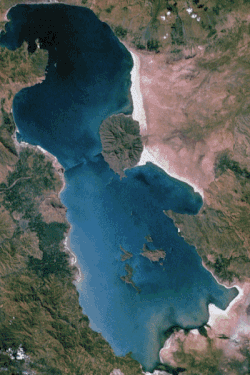
Lake Urmia from space in 1984
|
| Coordinates |  37°42′N 45°19′ECoordinates: 37°42′N 45°19′E 37°42′N 45°19′ECoordinates: 37°42′N 45°19′E |
|---|
| Type | salt (hypersaline) lake |
|---|
| Primary inflows | Zarriné-Rūd, Simineh-Rūd,Mahabad River, Gadar River, Barandouz River,Shahar River, Nazlou River,Zola River, Qatur River,Kaftar Ali Chay, Aji Chay,Boyuk Chay, Rudkhaneh-ye Qal'eh Chay, Qobi Chay,Rudkhaneh-ye Mordaq,Leylan River |
|---|
| Primary outflows | none: all water entering the lake is lost throughevaporation |
|---|
| Basin countries | Iran |
|---|
|
|---|
| Max. length | 140 km (87 mi) |
|---|
| Max. width | 55 km (34 mi) |
|---|
| Surface area | 5,200 km2 (2,000 sq mi) |
|---|
| Max. depth | 16 m (52 ft) |
|---|
|
|---|
| Islands | 102 (see list) |
|---|
Diminishing of surface of lake Urmia
Along with
Lake Van and
Lake Sevan, Urmia was considered one of the three great lakes of the historical
Armenian Kingdom, collectively referred to as the 'Seas of Armenia'.
Names and etymologies[edit]
Currently the lake is named after the provincial capital city of
Urmia, originally an
Assyrian name meaning Puddle of water. However, in the early 1930s, it was called Lake Rezaiyeh (
Persian: دریاچه رضائیه) after
Reza Shah Pahlavi, it was after the
Iranian Revolution in the late 1970s, that the lake was renamed Urmia. Its ancient
Old Persian name was Chichast (meaning, "glittering"–a reference to the glittering mineral particles suspended in the lake water and found along its shores). In medieval times it came to be known as Lake Kabuda (Kabodan),
[4] from the word for "azure" in
Persian, or 'կապույտ' ("Kapuyt/Gabuyd") in
Armenian. The
Latin name was Lacus Matianus so it is referred to in some texts as Lake Matianus or Lake
Matiene.
Locally, the lake is referred to in
Persian as دریاچه ارومیه, Daryāche-ye Orūmiye; in
Azerbaijani as Urmu gölü, ﺍﻭﺭﻣﻮ ﮔﺆﻟﻮ, and in
Kurdish as Wermy. The
Armenianname is Կապուտան ծով, Kaputan ts'ov.
History[edit]
O
ne of the early mentions of Lake Urmia is from the Assyrian records from 9th century BCE. There, in the records of
Shalmaneser III (reign 858–824 BCE), two names are mentioned in the area of Lake Urmia: Parsuwash (i.e. the
Persians) and Matai (i.e. the
Mitanni). It is not completely clear whether these referred to places or tribes or what their relationship was to the subsequent list of personal names and "kings". But Matais were
Medes and linguistically the name Parsuwash matches the
Old Persian word pārsa, an Achaemenid ethnolinguistic designation.
[5]
The lake was the center of the
Mannaean Kingdom. A potential Mannaean settlement, represented by the ruin mound of
Hasanlu, was on the south side of the lake. Mannae was overrun by the people who were called
Matiani or Matieni, an
Iranian people variously identified as
Scythian,
Saka,
Sarmatian, or
Cimmerian. It is not clear whether the lake took its name from the people or the people from the lake, but the country came to be called
Matiene or Matiane, and gave the lake its Latin name.
Chemistry[edit]
The main
cations in the lake water include Na+, K+, Ca2+, Li+ and Mg2+, while Cl−, SO42−, HCO3− are the main
anions. The Na+ and Cl− concentration is roughly four times the concentration of natural seawater.
Sodium ions are at slightly higher concentration in the south compared to the north of the lake, which could result from the shallower depth in the south, and a higher net evaporation rate.
The lake is divided into north and south, separated by a
causeway in which a 1.5-kilometre (0.93 mi) gap provides little exchange of water between the two parts. Due to drought and increased demands for
agricultural water in the lake's basin, the salinity of the lake has risen to more than 300 g/litre during recent years, and large areas of the lake bed have been desiccated.
[6]
The Fist of Osman, Lake Urmia's smallest island
[7]
Ecology[edit]
See also:
Geography of Iran and
Environmental issues in Iran
The recent drought has significantly decreased the annual amount of water the lake receives. This in turn has increased the salinity of the lake's water, lowering the lake viability as home to thousands of migratory birds including the large
flamingo populations. The salinity has particularly increased in the half of the lake north of the
causeway.
The lake is marked by more than a hundred small, rocky islands, which serve as stopover points during the migrations of several wild birds including
flamingos,
pelicans,
spoonbills,
ibises,
storks,
shelducks,
avocets,
stilts, and
gulls.
By virtue of its high
salinity, the lake no longer sustains any
fish species. Nonetheless, Lake Urmia is considered a significant natural habitat of
Artemia, which serve as food source for the migratory birds such as
flamingos.
[13] In early 2013, the then-head of the Iranian Artemia Research Center was quoted that Artemia Urmiana had gone extinct due to the drastic increases in salinity. However this assessment has been contradicted.
[14]
The lake is a major barrier between two of the most important cities in
West Azerbaijan and
East Azerbaijan provinces,
Urmia and
Tabriz. A project to build a highway across the lake was initiated in the 1970s but was abandoned after the
Iranian Revolution of 1979, having finished a 15 km causeway with an unbridged gap. The project was revived in the early 2000s, and was completed in November 2008 with the opening of the 1.5 km
Urmia Lake Bridge across the remaining gap.
[15] The highly saline environment is already heavily rusting the steel on the bridge despite anti-corrosion treatment. Experts have warned that the construction of the causeway and bridge, together with a series of ecological factors, will eventually lead to the drying up of the lake, turning it into a salt marsh which will directly affect the climate of the region. Lake Urmia has been shrinking for a long time, with an annual evaporation rate of 0.6m to 1m (24 to 39 inches). Although measures are now being taken to reverse the trend
[16] the lake has shrunk by 60% and could disappear entirely.
[16] Only 5% of the lake's water remains.
[17]

Bridge construction over Lake Urmia in 2005
On 2 August 2012,
Mohammad-Javad Mohammadizadeh, the head of Iran's Environment Protection Organization, announced that
Armenia has agreed on transferring water from Armenia to counter the critical fall in Lake Urmia's water levels, remarking that "hot weather and a lack of precipitation have brought the lake to its lowest water levels ever recorded". He added that recovery plans for the lake include the transfer of water from Eastern Azerbaijan Province. Previously, Iranian authorities had announced a plan to transfer water from the
Aras River, which borders Iran and
Azerbaijan; the 950-billion-
toman plan was abandoned due to Azerbaijan's objections.
[18]
In July 2014, Iran President Hassan Rouhani approved plans for a 14 trillion rial program (over $500 million) in the first year of a recovery plan. The money is supposed to be used for water management, reducing farmer's water use, and environmental restoration. Several months earlier, in March 2014, Iran's Department of Environment and the United Nations Development Programme (UNDP) issued a plan to save the lake and the nearby wetland, which called for spending $225 million in the first year and $1.3 billion overall for restoration.
[19]
Satellite imagery from 1984 to 2014 revealing Lake Urmia's diminishing surface area (video)
Palaeoecology[edit]
A
palynological investigation on long cores from Lake Urmia has revealed a nearly 200 kyr record of vegetation and lake level changes. The vegetation has changed from the Artemisia/grass steppes during the glacial/
stadialperiods to oak-juniper steppe-forests during the
interglacial/interstadial periods. The lake seems to have had a complex hydrological history and its water levels have greatly fluctuated in the geological history. Very high lake levels have been suggested for some time intervals during the two last glacial periods as well as during both the Last Interglacial as well as the
Holocene. Lowest lake levels have occurred during the last glacial periods.
Islands[edit]
The lake's largest island,
Shahi Island, is the burial place of
Hulagu Khan, the grandson of
Genghis Khan and the sacker of
Baghdad. In 1967, the Iranian Department of Environment sent a team of scientists to study the ecology of Shahi Island. Various results of the study which included the breeding habits of
brine shrimp were published by Javad Hashemi in the scientific journal, Iranian Scientific Sokhan.
Basin rivers[edit]
Environmental rallies[edit]
Recently, Lake Urmia faces the danger of drying out and the local Azeri population holds the Iranian regime accountable suspecting that the neglect for Lake Urmia’s environmental problems stems from the Iranian government’s deliberate policy to depopulate the area densely populated by an ethnic minority – the Azerbaijani people.
[24]
- On 2 April 2010 and 2011, and after several callings from Tractor Sazi F.C.'s fans in stadiums[25][26] and internet sites, protest demanding that the government take action to save Lake Urmia was held in Tabriz, Urmia, on the lake beach, and on top of the lake bridge. As a result, dozens of people were arrested by security forces.[27][28][29]
- In August 2011, after the Iranian parliament dropped two emergency cases for reviving the lake, a number of soccer fans at Tabriz derby (soccer match between Tractor Sazi F.C. and Shahrdari Tabriz F.C.) were arrested for shouting slogans in favor of protecting the lake.[30] Later that same week, Iranian Azerbaijanians scheduled a protest against the parliament move. Despite the capture of more than 20 activists by security forces the day before the protest, numerous people attended the event in Urmia and a number of clashes with police were reported[31][32]
- On 3 September 2011, Iranian Azerbaijanians demonstrated for second week in a row to protect Lake Urmia.[33] The protests in Tabriz and Urmia reportedly followed parliament's rejection of rescue plan, and security forces used violence to break up environmental rallies as protesters demanded action to save Lake Urmia,[34] and according to West Azerbaijan's governor, at least 60 supporters of the lake were arrested just in Urmia and dozens in Tabriz because, according to an Iranian official, they had not applied for a permit to organize a demonstration.[35] On August 2014 a protest campaign for saving the dying lake appeared on a video posted on social media showing a girl speaking in her native language Azeri Turkish " I'm from South Azerbaijan, for saving (to save) Lake Urmia and because of (Iranian president) Mr. Rouhani's failure to keep his promise on saving Lake Urmia, I'm calling him for the Salt Bucket Challenge" then pouring a bucket of salt on herself.[36]
In popular culture[edit]
For Azeri Turks the fate of Lake Urmia is a national, social, and economic issue and regarded as part of the Azerbaijani civilization.
[38] Lake Urmia was the setting of the fictional Iranian film
The White Meadows (2009), which featured fantastic-looking lands adjacent to a salt sea. There are many popular songs about Lake Urmia in Azeri Turkish such as "Urmu Golu Lay Lay"
[39]
See also[edit]
References[edit]
- Jump up
^ Henry, Roger (2003) Synchronized chronology: Rethinking Middle East Antiquity: A Simple Correction to Egyptian Chronology Resolves the Major Problems in Biblical and Greek Archaeology Algora Publishing, New York,
p. 138,
ISBN 0-87586-191-1
- Jump up^ E. J. Brill's first encyclopaedia of Islam, 1913–1936, vol. 7, page 1037 citing Strabo and Ptolemy.
- Jump up^ "Britanica". Britannica.com. Retrieved 4 September 2011.
- Jump up^ See, e.g. the Shahnama.
- Jump up^ cf. Skjærvø, Prods Oktor (2006), "Iran, vi(1). Earliest Evidence", Encyclopaedia Iranica, Vol. 13
- Jump up^ Alireza Asem, Fereidun Mohebbi and Reza Ahmadi (2012). "Drought in Urmia Lake, the largest natural habitat of brine shrimpArtemia" (PDF). World aquaculture 43: 36–38.
- Jump up^ "Saline Systems; Urmia Salt Lake, Iran". Salinesystems.org. Retrieved 4 September 2011.
- ^ Jump up to:a b "UNESCO Biosphere Reserve Directory".
- Jump up^ Rezvantalab, Sima and Amrollahi, Mohammad H. (2011) "Investigation of Recent Changes in Urmia Salt Lake"International Journal of Chemical and Environmental Engineering. 2(3): pp. 168–171
- Jump up^ Yakhchali, M. and Khalili Gholmankhane, N. (2003) "A Survey on Helminth Infection (Flotation Method) in Cervus Linnaeus(Iranian Yellow Deer) in Ashk Island of Lake Urmia" Pajouhesh & Sazandegi 58: pp. 26–27 Abstract
- Jump up^ Ramsar Sites Information Service
- Jump up^ ProtectedPlanet - Urumieh lake
- Jump up^ C. Michael Hogan. 2011. Lake Urmia. Eds. P. Saundry & C. J.Cleveland. Encyclopedia of Earth. National Council for Science and the Environment. Washington, D.C.
- Jump up^ Critical condition of Artemia Urmiana and possibility of extinction
- Jump up^ "Iran's East and West Azarbaijan Provinces Conntected by Lake Orumiyeh Bridge". Payvand.com. Retrieved 4 September2011.
- ^ Jump up to:a b Karmi N. Iran's largest lake turning to salt. Associated Press 25 May 2011.http://news.yahoo.com/s/ap/20110525/ap_on_re_mi_ea/ml_iran_environmental_disaster/print
- Jump up^ Erdbrink, Thomas (30 January 2014). "Its Great Lake Shriveled, Iran Confronts Crisis of Water Supply". New York Times.Archived from the original on 31 January 2014.
- Jump up^ http://www.payvand.com/news/12/aug/1010.html
- Jump up^ http://www.newscientist.com/article/dn25850-iran-to-spend-500-million-to-save-shrunken-lake-urmia.html#.U7nrg41dXvI
- Jump up^ "Completed by the end of the 94 dams Silveh Piranshahr" (in Persian). Kurd Press. 23 August 2014. Retrieved 20 January2015.
- Jump up^ "Silveh Dam and Irrigation and Drainage" (in Persian). Omran Iran - Deputy Governor of West Azerbaijan. Retrieved20 January 2015.
- Jump up^ Edris Merufinia, Azad Aram, Fatemeh Esmaeili (2014). "Saving the Lake Urmia: from Slogan to Reality (Challenges and Solutions)" (PDF). Bulletin of Environment, Pharmacology and Life Sciences 3 (3). ISSN 2277-1808. Retrieved 20 January2015.
- Jump up^ List from: Farahang-e Joghrafiyayi-e shahrestânhâ-ye Keshvar (Shahrestân-e Orumiyeh), Tehran 1379 Hs.
- Jump up^ Iranian regime is killing Lake Urmia-Umud Duzgun: http://yurd.net/pageE.php?id_contents=0000002754
- Jump up^ "A video from slogan "Let's cry and fill Lake Urmia with our tears", in Azeri Turkic : Gəlin Gedək Ağlayaq Urmu Gölün Dolduraq". Youtube.com. 13 October 2010. Retrieved 4 September 2011.
- Jump up^ "A video from slogan "Let's cry and fill Lake Urmia with our tears", in Azerbi Turkic : Gəlin Gedək Ağlayaq Urmu Gölün Dolduraq". Youtube.com. 30 November 2010. Retrieved 4 September 2011.
- Jump up^ "Iranian greens fear disaster as Lake Orumieh shrinks". The Guardian (London). 5 September 2011.
- Jump up^ "Video: Urmiye Gölü - İran polisi etirazçılara daş atır! (2 April 2010)". Youtube.com. 6 April 2011. Retrieved 4 September2011.
- Jump up^ "Video:Təbriz şəhərində 13 Fərvərdin 1390 (2 April 2011)'da geçirilən Urmu gölü mitingindən görüntülər". Youtube.com. 2 April 2011. Retrieved 4 September 2011.
- Jump up^ Mackey, Robert (30 August 2011). "Protests in Iran Over Disappearing Lake". Iran: New York Times. Retrieved4 September 2011.
- Jump up^ "Rally protesting Iran over Lake Urmia turns violent". Hurriyet Daily News. Retrieved 4 September 2011.
- Jump up^ "Iranian Protest Urges Help for Shrinking Lake". San Francisco Chronicle. 30 August 2011. Retrieved 4 September 2011.
- Jump up^ "Tabriz Demonstration Sep.3.2011 (12 Shehriver 1390) to protect Lake Urmia". Youtube.com. Retrieved 3 September 2011.
- Jump up^ "Iran police break up environmental protests". euronews.net. Retrieved 4 September 2011.
- Jump up^ "Iran arrests saltwater lake protesters". BBC. 4 September 2011. Retrieved 4 September 2011.
- Jump up^ Salt Bucket Challenge Campaign https://www.facebook.com/video.php?v=364860460332865&set=vb.362882447197333&type=2&theater
- Jump up^ "Azeri Turks in Ankara protest Lake Urmia drying up". todayszaman.com. Retrieved 4 September 2011.
- Jump up^ Iranian Regime is killing Lake Urmia-Umud Duzgun:http://yurd.net/pageE.php?id_contents=0000002754
- Jump up^ https://www.youtube.com/watch?v=dLB9bLOKalY
Note: Provided information are copied directly from Wikipedia.com and does not reflect my point of view in anything. This is just a short cut through the information about the Lake. It is also recommended that information on the site may change often therefore, do not pretend to cite it in academic articles.


